 |
|
The
Desert Winter Thru-Hike (WTH!) mapset
| BETA
release |
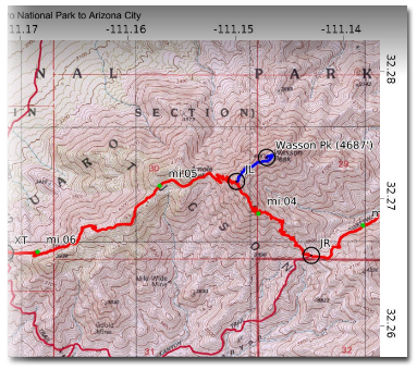
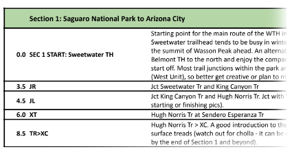
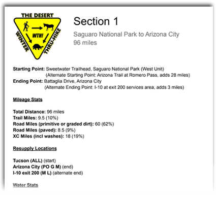
The Desert Winter Thru-Hike (WTH!) is an adventurous 800-mile hiking route highlighting 20 Wilderness Areas, 7 National Parks and Monuments, and remote protected lands of the Sonoran, Colorado, and Mojave deserts. Featuring mainly low to mid elevation desert valleys and mountain ranges occurring at lower latitudes of the American Southwest, the Desert WTH offers a true winter season thru-hiking option for very experienced walkers looking to extend the US hiking season into the December - February timeframe. And yet despite the aridity and remoteness of this warmer region, the route has been carefully crafted to greatly reduce or eliminate the need for caching water in advance, while also providing easy access at its termini both to begin and end the long hike. The 2022-2023 beta mapset for the WTH consists of detailed, navigation-ready printable maps as well as georeferenced PDF maps for use in the free Avenza GPS app. We also have a complete resource for the Gaia GPS app including tracks and detailed waypoints for the entire route. For this season, the printable mapset runs from Section 1 (Saguaro NP) through Section 5 (AZ / CA state line). Due to less certainty over a finalized routing in California, Sections 6 through 8 are currently only navigable using Avenza and/or Gaia. Additionally theres a complete 70+ page print-friendly Databook as well as a Water Chart (interactive google sheet), both of which can be cross-referenced with the other resources. A summary-style town / resupply guide assists with planning. This mapset also contains overview maps, elevation profiles, and section descriptions, together describing the route's location, length, terrain, and important information between each of its resupply points. All map and data pages are in the common PDF format and are standard letter-size (8.5 x 11") for home printing as well as easy uploading to document printing websites such as FedEx Office. System requirements: Digital download (300MB) can be accessed in the Cloud via PC, Mac, Android or iOS. Color InkJet or LaserJet printer recommended if printing at home. Adobe Acrobat Reader recommended for viewing and home printing of PDF maps. Avenza is a free app available for iOS and Android that can optionally be used for GPS-based navigation with our Avenza-compatible PDF maps. GaiaGPS is a subscription-based app for iOS and Android that can optionally be used for GPS-based navigation with our Gaia-ready folder of tracks and waypoints.
Disclaimer: While it is our hope and endeavor that the Desert WTH digital mapset will allow experienced users to avoid most navigational problems and will contribute to a rewarding adventure along the route, we do not guarantee the 100% accuracy of these maps and GPS data and other information provided, and assume no responsibility for their use or misuse. Hiking and backpacking are inherently risky activities, so be sure to use these maps as part of an overall approach to maintaining safety in the backcountry, and do not assume their endorsement of a particular road, trail, or creek crossing, etc. Conditions in the field can change, sometimes quickly, and property boundaries can be redrawn to exclude public access. In short, use the maps and benefit from them, but use your skills and your awareness too. And always keep your options open when determining the safest and most practical direction of travel.
Copyright © 2024 Simblissity Ultralight Designs |
| ||||||||||||||||||||||||||||||||||||||