G.E.T.
Guidebook
Segment 8: Santa Teresa Wilderness 36.0
miles  Guidebook
Home Guidebook
Home
Open
this page for printing
Submit
feedback for this segment
|
Segment
Length | Segment
Status | Season |
|
|
|
36.0
mi. | finalized
& accessible | spring
& fall | | Resources |
| OVERVIEW
MAP | 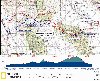 |
| ELEVATION
PROFILE |  |
G.E.T. Topo Maps 21-28
Town Guide: Klondyke
Water Chart
Image Gallery: Album 3
| Additional
maps:
Coronado
N.F. Safford & Santa Catalina Ranger Districts (USFS)
Land management agency:
Coronado
National Forest Safford Ranger District |
| Beginning
access point | | Ending
access point | |
Aravaipa Canyon Wilderness
east trailhead. (NOTE: An Aravaipa Canyon Wilderness use permit must be obtained
before arrival here if entering the Wilderness in Seg 7.
From I-10
at Willcox: Take Exit 340 north (left) toward Bonita along the Ft. Grant Road.
At the "T" in Bonita, turn left and go 38 miles to the East trailhead on graded
dirt Aravaipa Canyon Rd.
From US 70 at Safford: Take US 70 west past
Pima and turn left on Klondyke Road (turnoff marked Aravaipa Rd). On this graded
dirt road, go 24 miles to the "Y" intersection, turn right and go another 16 miles
to the trailhead, which is near the junction of Aravaipa and Bear canyons.
NOTE: Several shallow crossings of Aravaipa Creek are normally encountered within
the last few miles to the trailhead. | |
Off of Klondyke Road.
From Safford, take US 70 west past Pima and turn left on Klondyke Road (signed
Aravaipa Rd). Follow this graded dirt road appx. 18 mi. where a white metal sign
and adjacent road sign "Lazy JM Ranch Rd" indicates a side road at right
(waypoint 09010). This is the end of Segment 8. Follow the dirt side road half
a mile N and park off the road, beside the wash. (Don't park near or block the
gate to the east.) Another option is to continue on Klondyke Rd another mile to
signed turnoff for Sand Tank/Trail 66. Follow this road (FR 677) 2.2 mi. A large
dirt turnout is available here, by a 3-way road junction (waypoint 08840). Parking
here offers access to the Buford Hill alternate route. To reach the main GET,
continue on foot 1.1 mi via now-4WD FR 677, toward Sand Tank. |
SEGMENT
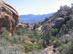
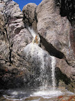
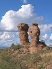
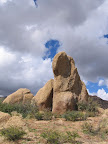
OVERVIEW Jaw-dropping.
This is the expression that came to mind (and face!) upon the author's first glimpse
of Holdout Canyon in the Santa Teresa Wilderness. A wonderland of oddly shaped
pinnacles, fins, and domes completely overwhelmed the scene before me, a vantage
made all the more incredible by the unexpectedness of it all. Nothing I'd read
about the area had quite prepared me for the wilderness of rock I was about to
enter. The Santa
Teresa Mountains are comprised of an upthrusted and eroded granitic batholith
similar in geology and appearance to the "Wilderness of Rock" area of the Santa
Catalina Mountains near Tucson, though arguably on a grander scale. Like the Catalinas,
the Santa Teresas are a Sky Island range, rising boldly from the surrounding desert
and capped with an isolated montane community of flora and fauna. Yet the Santa
Teresa Wilderness remains comparatively obscure and is seldom visited, partly
owing to the sheer ruggedness of this range's splendor. (Legend has it that the
name Holdout Canyon recalls Old West outlaws who once eluded justice among the
maze of boulders here.) The other reason for the range's modern-day esoterica
relates to trailhead access. Many of the forest roads that approach the Wilderness
boundary cross private inholdings with locked gates and no public access, while
the few remaining trailheads are accessible only by high-clearance 4WD. (2WD vehicles
can access this segment near its end points, but foot travel is then required
to reach the Forest and Wilderness boundaries.)
Perhaps not surprisingly, foot trails in the Santa Teresa Wilderness are little-used
and run the gamut from rough-but-followable to abandoned and non-discernible.
This segment of the GET attempts to navigate both the trail condition and access
concerns, and the upshot is a notably long, rugged and challenging walk with several
options for travel available. If you're acclimated to hiking in the wilder reaches
of southern Arizona's mountain ranges and are comfortable with the possibility
of occasionally losing the trail in remote terrain, then by all means consider
following this segment's main route through the Santa Teresa Wilderness. Otherwise
you might consider following an easier, alternate route around the wilderness
(the Buford Hill alternate) in order to complete this segment. (Those prepared
to meet this wilderness area's challenges will be duly rewarded for their efforts,
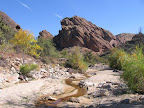
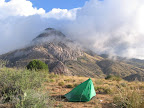
as veteran GET hikers will attest.) Flowing
surface water is occasionally in short supply in the modestly-sized Santa Teresas,
though the community of Klondyke as well as nearby Fourmile Canyon Campground
have water available year-round, and springs, rock pockets, stock ponds and troughs
are encountered sporadically along the route. Most long-distance hikers will probably
also want to send a resupply parcel to Klondyke, which is located directly along
a suggested alternate route. Plan to budget about two to two-and-a-half days of
food between Klondyke and segment's end if going through the Wilderness (not including
any down time in Klondyke environs).
ROUTE
DETAILS In
essence, there are three alternate routes in this segment - the Turkey Creek
alternate near the beginning that offers a more adventurous way of hiking
into Klondyke for those so inclined, the Black Rock Canyon alternate that
detours around Holdout Canyon within the Santa Teresa Wilderness to make travel
a bit easier without missing too much of the good stuff, and the Buford Hill
alternate that detours entirely - and far less scenically - around the Santa
Teresa Wilderness and its rough, challenging trail conditions. The Turkey Creek
and Buford Hill alternate routes begin or end at Klondyke, which itself is 2.4
miles south of the main GET route. (Refer to the Overview
Map in order to visualize this.) Less experienced desert hikers may at least
want to use the Buford Hill alternate. Using this alternate alone, the segment's
total mileage is about 15 miles shorter than as stated at the head of this page.
| |
Main
GET route
only | Main
route with
Black Rock alternate |
Main
route with
Buford Hill alternate |
Turkey
Creek alternate
& main route |
Turkey
Creek &
Buford Hill alternates | |
Total
Segment
Mileage | 36.0
miles | 37.0
miles | 21.9
miles | 45.5
miles | 26.6
miles |
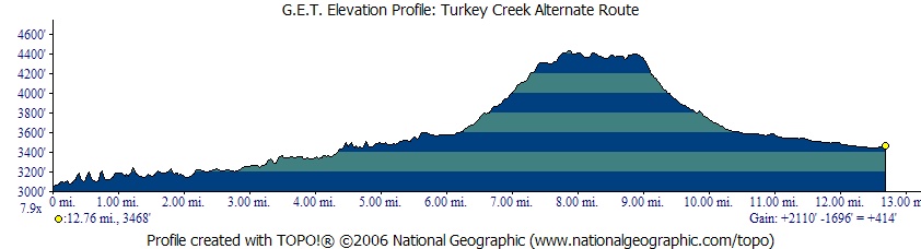
ALTERNATE
ROUTE: TURKEY CREEK
| ELEVATION
PROFILE | 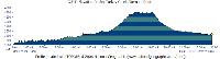 |
The Turkey Creek
alternate begins 2 miles west of this segment's starting point (the Aravaipa
Canyon Wilderness east trailhead). Hikers planning to resupply in Klondyke, or
who intend to make use of the Buford Hill alternate route, or who are simply looking
for an adventurous route up a remote, water-sculpted canyon that harbors a cliff
dwelling, all may find this alternate route preferable to the initial, roaded
portion of the main route in this segment. The Turkey Creek alternate heads south
up Turkey Creek, then turns east to follow 4WD roads over a bench, before joining
2WD road in Fourmile Canyon and terminating at Klondyke. From
the junction of Aravaipa Canyon and Turkey
Creek, the alternate route heads south up the canyon of Turkey Creek via rough
4WD track. The creek does not always flow, but the likelihood increases farther
up the canyon. At 1.3 miles, a short trail leads to a cliff dwelling. Built
by prehistoric Salado indians, the dwelling is over 700 years old and is among
the best preserved structures of its kind in the Southwest. At
2.6 (waypoint 07510) the rough, 4WD "Rug Road" leaves the canyon,
climbing to the west. This road is part of the Aravaipa Canyon Wilderness bypass
route detailed in Segment 6. Continue
up Turkey Creek's canyon, veering left at a 4WD junction (the right fork heads
toward a corral near the mouth of Oak Grove Canyon). Our track soon joins the
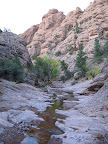
sandy wash of Turkey Creek itself. Within a half mile the canyon narrows, with
sheer and colorful cliffs on display. A carsonite post sometimes in place here
indicates the way ahead is open to foot and equestrian use only. The cross-country
hiking ahead is rugged, but the canyon winds pleasantly in the company of tall
cottonwoods, willows, and ash, sometimes with pools or
flowing water in spots. Using care to follow the main drainage of Turkey
Creek as it branches, reach an area where the canyon floor is choked with massive
boulders shorn from the cliffs, at 5.6 (waypoint 07525) - a fun little
obstacle course. Join
a 4WD track beyond the corral near 6.3, which soon climbs away from Turkey
Creek on the left (east). In a mile reach a junction on a ridge, and turn right
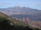
(south). Enchanting scenery extends in every direction, and includes the Santa
Teresa and Pinaleno ranges toward the east, Galiuros to the south, and the fantastically
eroded forms in upper Turkey Creek nearby. The rough road bends northeast around
the head of a drainage near 8.4 (waypoint 07560), then turns southeast
to begin a descent into Fourmile Canyon. Reach graded, unpaved Fourmile Creek
Road at 10.4 (waypoint 07570), and turn left (east), passing Fourmile
Canyon Campground in 1.4 miles (with water and toilets - see Town
Guide). The alternate route ends at the road junction in Klondyke,
at 12.7. From here, the main GET route is 2.4 miles north via Aravaipa-Klondyke
Road. 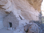

To
instead follow the main route from Aravaipa Canyon Wilderness east trailhead,
proceed eastbound on dirt 2WD Aravaipa Canyon Road, here within the Nature Conservancy's
Aravaipa Canyon Preserve, where camping is not allowed. The pale cliffs of "The
Chimney" rise prominently from the south bank of nearby Aravaipa
Creek, while shady cottonwood branches arch over the road. At 0.4
miles, the road leaves Nature Conservancy land temporarily. At 0.7, you
may encounter a gate across Aravaipa Canyon Road. A landowner at the adjacent
house has in the past claimed ownership of the road across her property, though
as of this writing the matter appears to have been resolved. In any case, if the
gate is closed but not locked, then open it, pass on through, and be sure to close
it behind you. If it happens to be locked, this is intended to deter vehicles
rather than pedestrians, so do proceed to climb over the (low, manageable) gate
unless instructed otherwise. Beyond the gate, re-enter Nature Conservancy land,
soon passing the historic Salazar family church, with a "visitors welcome"
sign out front. Cross
a normally shallow Aravaipa Creek along the road at 1.5. The surrounding
hillside vegetation consists of mesquite and juniper, a marked change from Aravaipa
Canyon and evidence of the route's departure from a true Sonoran desert environment,
which here does not extend east of the Galiuro Mountains. Another crossing passes
near the Aravaipa Canyon Preserve host's residence. At a third crossing, consider
filling water bottles as needed, as Aravaipa Creek
is typically dry as you continue upstream. Pause
to feed the Detroit
Dinosaur at 2.9 - apparently he'll take scraps. (Sadly, this particular
dinosaur appears to have gone extinct in recent years, but keep an eye out just
in case.) Leave signed Nature Conservancy property again at 3.9, (Cobra
Ranch, which you enter here, is in fact now owned by the Conservancy as well)
then cross the now-dry creekbed at 4.3. Beyond the bend, an unmarked forest
road heads north at 4.5 (waypoint 08080). Older Forest Service maps label
this road as FR 277, but FR 277 is actually reached at 5.0 (waypoint 08090)
along with a sign for "Landman Camp" (as of 2013 the road at 5.0 may
not be signed at all, and may in fact be closed). Continue straight on what's
now known as Aravaipa-Klondyke Road, with the pinnacled profile of the Santa Teresa
Mountains now looming ahead. The
main GET route passes signed FR 94 on the left at 5.6 (waypoint 08100)
(re-signed in 2010 as '941' on a carsonite post by the junction). A fairly reliable
stock trough is located half a mile north
on this road. Continuing on Aravaipa-Klondyke Rd, in less than 50 ft reach a junction
with an unsigned dirt 2-track on the left (east) (waypoint 08110). From this junction,
the community of Klondyke is 2.4 miles south
on Aravaipa-Klondyke Rd, with water, maildrop service (no outgoing mail), seasonal
lodging, and a campground nearby. (See the Town
Guide for more info on Klondyke.) Beyond
5.6, the main GET route becomes somewhat challenging to follow within the
Santa Teresa Wilderness, where an occasionally vague, cairned trail in Holdout
Canyon demands decent navigational skills and a willingness to dedicate some extra
time and effort here. For those so prepared, this Wilderness route can provide
a rewarding and memorable experience. For those less inclined, refer to the description
for the Buford Hill alternate route at the end of this chapter, which begins
in Klondyke, follows a network of dirt roads, and in 13.9 miles ends back at the
main route along Klondyke Road at the interface of segments 8 and 9. At
5.6, the main GET turns left (east) onto the sandy 2-track. (As of 2012
this road as well as FR 941 just to the north both feature aluminum swinging vehicle
gates that are typically left open, or might be latched but not locked.) The road
soon joins a wash. Proceed east up the wash, then where the wash branches, keep
to the right side to 6.2 (waypoint 08115), where the now-well-defined 4WD
road climbs away. The road provides a steady, moderate grade along the crest of
a low ridge, with far-ranging views toward the Galiuro Mountains beyond Aravaipa
Valley and to the Santa Teresa Mountains ahead. After a brief dip near 7.7,
climbing resumes, with a switchback along the road. At 8.3 reach a 4-way
junction and keep straight, continuing uphill along the ridge. (The left fork
leads to an unreliable stock pond in 0.2.) At
8.8, reach the Coronado National Forest boundary by a gate. A faded wooden
sign indicates "Reef Basin Trail 68" along with mileages to Reef Tank
and Holdout Creek. Fifty feet beyond the gate at a cairn, turn right off the road
onto Trail 68. The bench-cut trail traverses northeast among prickly pear, agave,
ocotillo and mesquite to reach the drainage of Laurel
Canyon at 9.2 (waypoint 08140) (sometimes flowing in spring,
or with pools). Trail tread briefly becomes obscure, but there are occasional
cairns, as it crosses the drainage and heads up along its sandy east bank to enter
a steep-walled box. Here, as the drainage bends left, look for the trail where
it climbs away at right. The rough trail winds over a low ridge, then soon returns
to the drainage (a right prong of Laurel Canyon). It proceeds directly across
the rocky wash, then uphill along a ridge, passing through an open gate at 9.5.
Again the trail returns to the drainage (another prong), continuing straight across
it. Now it passes over a height-of-land, then proceeds north to enter an open
flat. Cairns may mark where it soon crosses a wash. Beyond, Trail 68 enters a
forested pinyon pine environment, then ends back in the open at Reef
Tank, a large, seasonal stock pond that may harbor waterfowl when wet
(10.2, elev. 4980'). (Westbounders, leaving Reef Tank, watch for where
the trail soon splits and take the right fork, avoiding the stock path that continues
straight and becomes increasingly vague.) Alternate
route within the Santa Teresa Wilderness: All trails within this Wilderness
area can be considered primitive in character and may be difficult to follow for
brief stretches at a time, and this may be particularly true of Holdout Canyon.
Despite being intensely scenic, this canyon nonetheless can be bypassed by following
the Black Rock Canyon Alternate from Reef Tank, via 4WD roads north and
east into Black Rock Canyon. From the Wilderness boundary at a fenceline, a rough
but obvious swath descends steeply into this canyon. Trail 292 then heads east
down the canyon's main, sandy / rocky drainage without tread or signage, but also
without any routefinding concerns. (Westbound, just be careful to choose the correct
fork heading up the wash.) The total distance is about a mile longer than the
main route through Holdout Canyon. The Black Rock Canyon alternate may be a good
option for experienced desert hikers who don't wish to compromise too much when
it comes to exploring this remarkable range, but who want to make life just a
bit easier than otherwise. To
follow the main GET route toward Holdout Canyon from Reef Tank, walk clockwise
around the tank to its north side. (Westbounders, unsigned Trail 68 leaves
the tank on its south side.) Camping is possible here, and a 4WD road that
ends nearby is little-used by vehicles. A small cairn may indicate where unsigned
Holdout Canyon Trail 69 climbs away to the northeast (waypoint 08190). Follow
the trail over a minor north-south ridge, then down along its east side to cross
a shallow, brushy drainage. The trail climbs and contours to another low ridge,
then again across a drainage. It repeats the theme one more time, then at 10.8
enters the (unsigned) Santa Teresa Wilderness and heads southeast up a more prominent
drainage among pinyons and manzanita to crest a broad saddle at 11.4 (waypoint
08210, elev. 5180'). Views begin to open toward the higher terrain beyond, while
Holdout Canyon remains tantalizingly just out of sight. Descend gradually east
from the saddle, where the trail joins another drainage. Look carefully for where
the trail then leaves the rocky drainage on the left, contouring east away from
it to reach Holdout Overlook at 12.0. The view down Holdout Canyon and
of Pinnacle Ridge beyond is truly awe-inspiring, the myriad rock formations a
testament to the uncanny forces of geology and time. Now
Trail 69 contours southeast with the help of occasional small cairns, descending
gradually, often over bedrock, to reach a dry, rockbound tributary of Holdout
Creek at 12.2. Cairns guide the way across it, then soon back again to
its north side. Ahead, the amply-cairned trail passes through a gate then crosses
a broad area of bedrock among a haphazard array of boulders. The prominent rock
face to the east is called Holdout Tower, with other area features known (among
the rock climbing community) by such whimsical names as Zorro, Great Wide Face,
and The Shmoo. The
trail descends to a minor drainage at 12.7 (waypoint 08213), just north
of its confluence with Holdout Creek. The trail continues across the side drainage
and then reaches Holdout Creek (waypoint 08214),
which often flows in this vicinity. (Beyond in this description, the word "creek"
will be used to refer to this, the main drainage of Holdout Canyon, whether flowing
or not.) Proceed
down the left (north) side of the drainage, watching for where the trail heads
away from the creek again. The trail climbs above the drainage to contour along
a hillside, generally paralleling the drainage eastward. Here it enters a potentially
confusing area where the route is sometimes defined only by small cairns. Avoid
the temptation to return to the creek, which has pour-offs ahead. Instead, look
carefully for cairns as the brushy trail undulates across several minor side drainages.
In particular, be on the lookout for a cairned metal survey marker on the left,
where the trail turns sharply left (north) to circumvent an area of impassable
domes and gullies to the east. Now
the trail, cairned and flagged, descends into a forested side drainage. It leaves
the drainage at right to climb through a little notch, then down the bouldery
drainage on its opposite side. The trail leaves this drainage on the left, then
rejoins it farther down. It then makes a somewhat obscure right turn (south) into
another drainage, which it soon leaves at left. Finally the trail exits the maze
of rock and returns to Holdout Creek, reaching it by a cairn at 13.8 (waypoint
08215). (Westbounders, walking up the creek, watch for the cairn on the right.) Walk
cross-country down the creek to where the drainage forks at 13.9 (waypoint
08216) and take the left fork, northward. As the drainage bends east, remain on
its left (north) side. From here to 14.6 you'll encounter some semblance of a
paralleling trail back in the woods alongside the creek, interspersed with sections
of drainage walking; keep an eye out for cairns wherever the trail meets the creek.
Initially it returns to the drainage again in only 100 yards. Fifty yards beyond,
the trail leaves the drainage once more on the left, at a cairn atop a rock (14.1,
waypoint 08217). Still the trail remains near the creek and returns to it again,
crossing it here to its south side, which it follows briefly. It comes back to
the drainage at a bend, hopping the creek while remaining on the south bank, then
returns and crosses the creek to its north bank. From here to 14.6 the trail is
either on the north bank or, where obliterated by deadfall, just head down the
drainage. The trail leaves the creek decisively at 14.6 (waypoint 08219)
on its north side. Trail
69 is better established now, eventually turning north to enter a brushy, rocky
flat, with expansive views toward Pinnacle Ridge and Cottonwood Mountain. It bends
northeast across bedrock, with cairns, rising and dipping across a few minor drainages,
before descending to intersect riparian Holdout Creek again at 15.1 (waypoint
08220). A north-south side drainage joins here on the left. Walk up the side
drainage 20 feet to find a resumption of trail on the right. (Westbounders,
walk down the drainage to Holdout Creek and look for trail heading up the bank
at the 2 o'clock position.) Our
trail soon turns northeast, winding up alongside a little gully and over a height-of-land.
Beyond, low live oak scrub forms little corridors down the eroded hillside; be
careful to determine which one is the trail, which turns northeast here and descends
a bit. It then climbs north to a rockbound perch, and turns east along it, with
more good outlooks. Now the trail works its way north again, undulating toward
a fenceline on the right, which it follows, climbing to a gate at 15.7.
It then descends awkwardly beyond the gate over a gravelly surface of eroded granite,
passes over another minor height-of-land, then follows a network of steep, eroded
gullies north. Flagging may indicate which gully to follow, though it doesn't
really matter, as all of them soon reach the same destination: a prominent east-west
drainage. Join this drainage and follow it east a short ways to its intersection
with Holdout Creek at 16.1 (waypoint 08228). Turn left and walk cross-country
down the creek to its confluence with Black Rock Canyon
(waypoint 08230). (Westbounders turn left up Holdout Canyon and walk along
the right side of the wash 150 yards to an obvious side drainage on the right,
possibly marked with a cairn. Turn into the side drainage and look for trail which
climbs out at left.) An
old corral and pasture in Black Rock Canyon across from the confluence would make
for a scenic rest break or campsite, with fine views in a pretty, open area. The
way ahead is much more obvious now, as our route joins the wide wash in Black
Rock Canyon, following it eastbound, cross-country. This is so-called Trail 292.
If the wash isn't flowing you may still find sporadic pools in places. Keep to
the drainage, following the path of least resistance among the sand and cobbles,
and watching for coues whitetail deer and the tracks of black bear, coyote, and
mountain lion. At 16.8 (waypoint 08235) the first notable side drainage
enters on the left (north) - Fisher Canyon. Near
17.5, find an easy way around a fence across the wash, which must mark
the boundary between National Forest Wilderness and the BLM's companion North
Santa Teresa Wilderness, which we now enter. Eventually the prominent monolith
of Black Rock appears, drawing closer. A junction with Gardner Trail 67 on the
right side of the drainage, at 20.0 (waypoint 08240) is hard to locate,
and the faint trail itself hard to follow, but this is the easiest way to access
the challenging - and highly scenic - cross-country route ahead, which starts
at 20.6. DO NOT CONTINUE ANY FARTHER DOWN BLACK ROCK CANYON BEYOND 20.0.
The canyon enters private property with no public access allowed. Trail
67, which begins as an overgrown jeep track (you may need to hunt around the banks
of the wash to find it), soon
becomes pack trail, then passes through a gate in a fenceline at 20.6 (waypoint
08250). Here the GET leaves the trail and heads cross-country for about 3 miles,
the goal being to skirt private land and eventually pick up Cottonwood Mountain
Trail 66. The hiking is adventurous, with several noteworthy climbs and descents
in quick succession, but the terrain at least is relatively open and bearings
aren't hard to come by. Views along the way - toward Black Rock and up to Cottonwood
Mountain - are spectacular! Pass through the gate at 20.6, and immediately
turn left (southeast) along the fenceline. Soon leave the fence to head directly
up the hillside before you, keeping just left of a drainage that clefts the hillside.
As the grade slackens, veer left toward an area of exposed bedrock, cross a drainage
there, then continue heading uphill along the next little ridge until a game trail
crosses in a bouldery / cliffy area (waypoint 08260). Follow the game trail left
(east), working your way through the rocks until the terrain mellows in a broad
canyon, where the trail fades. Head up along the west side of the drainage, then
cross it heading due east, reaching another drainage fork in a bedrocky area at
around waypoint 08300. Turn northeast here, climbing and contouring gradually
up the ridge to your right. Crest the ridge, then head east, with the Black Rock
Ranch (a working guest ranch, the one we're now skirting) visible below, framed
by spectacular rhyolite outcroppings. Now descend to Cold
Spring Canyon, crossing the drainage near an east-west fenceline. The
drainage flows or has pools with some regularity (waypoint 08310). Keeping
the fenceline on your north, climb generally east over another ridge, then descend
just as quickly into the drainage beyond, where water may again be present at
times. Let the fenceline guide you up to the next ridge crest, then leave the
fence to follow the ridge southeast. Approaching waypoint 08322, find a game trail
that descends a short distance off the east side of the ridge to cross the steep-angled
drainage there, then try to remain on the game trail as it climbs briefly to another
ridge. The game trail may end here. Follow this ridge rather steeply downhill
to the northeast. Reach the familiar east-west fenceline at waypoint 08324 and
cross it, trading USFS / Santa Teresa Wilderness for BLM / North Santa Teresa
Wilderness, and continue down the ridge. Approaching Preacher Canyon, find any
path of least resistance off the ridge, preferably off the right side, which should
drop you onto a faint trail that parallels the main drainage on its west side.
Don't cross Preacher Canyon here, but instead follow the trail to the right, southeast,
to a defunct well or trough at waypoint 08326. Now cross the drainage of Preacher
Canyon, which may be flowing here or upstream less than a tenth of
a mile. Try to
follow a faint cow path, or network of paths, generally east and out of the drainage,
climbing up to the broad ridge beyond. The original Cottonwood Mountain Trail
66 is mostly lost here from disuse, but you'll pick up a much more evident portion
of it once crossing back into USFS land ahead. With the steepest climbing out
of the way, proceed southeast up along the wide grassy ridge, generally near its
southwest edge. Reach the BLM / USFS fenceline again around waypoint 08328 and
follow it due east to waypoint 08330 where it comes to a junction with a north-south
fence, at 23.4. You can cross the north-south fence here (without the assistance
of a gate). Then turn right through an opening in the east-west fence. Now in
the Coronado National Forest / Santa Teresa Wilderness once more, find evidence
of trail tread and potentially well-used cow pasture. Congratulations and nice
work! The wild and rewarding cross-country traverse ends here. Follow Cottonwood
Mountain Trail 66 south. (Westbounders, don't continue north on the trail,
which leads to a private ranch. Instead, from the fence opening at waypoint 08330,
hop the north-south fence and head cross-country down to Preacher Canyon.) Trail
66 soon becomes better defined as it switchbacks down along a steep hillside,
then across a riparian drainage. Next it climbs to pass an old metal camo-colored
tank and smaller trough (both likely dry) at 24.1. Ahead the trail reaches
a junction (look for the wooden signpost by a tree) at 24.4. Here a side
trail (better defined than the main trail) heads east into a corral, with a pair
of circular troughs located 50 yards north, downhill along the back fenceline,
by the drainage (waypoint 08342). This is generally known as Kane
Spring, although the map shows the spring back by the camo tank environs.
Trail 66 continues right at the signed junction, south, the less obvious of the
two forks. (Westbounders, turn right to visit the troughs, left for Trail 66.) Climb
steadily along the rocky but well-engineered trail, with occasional switchbacks.
Reach a gate at 26.0, where the trail emerges from shady pinyon and live
oak cover to cross over a saddle. To the east, a vantage exends to the broad Gila
Valley far below near Safford, with the desert Gila Mountains beyond. The trail
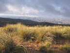
now enters the watershed of Fourmile Canyon, contouring southward along an east-facing
slope. Here and beyond the Santa Teresa Mountains burned sporadically in the late
1980's, the vegetation now well into regeneration but with many old pinyon snags
still standing in places. At 27.0, after crossing a few side drainages,
the primitive rather brushy trail changes character as it reaches the start
of a section which was reconstructed and cleared of vegetation in 2015. In fact
the high-level trail work and related improvements to the overall hiking experience
continues all the way to the Trail 66 trailhead at 31.6, representing a truly
impressive effort on the part of the forest service and volunteers who reportedly
camped out in the backcountry here for several weeks while on assignment. From
27.0 Trail 66 bends south, heading over a height-of-land, then slabs west, downhill,
to follow alongside the main drainage of Fourmile Canyon,
which flows seasonally and often has pools. (Westbounders reach a junction
beyond the height-of-land - options left, right or (seemingly) straight - and
turn left, contouring along the slope.) Cross
a fork of the drainage at 27.3 and turn right, the trail here lined with
defining rocks. (An attractive camp could be made among ponderosas in this general
area.) Proceed up alongside a fork of the drainage, leaving it at a switchback,
the first of several as Trail 66 climbs west between the two main forks here at
the head of Fourmile Canyon. Eventually the trail initiates a sidehill traverse,
(beyond waypoint 08370) where benched tread works its way gradually up to a ridge
crest around 28.0. Atop
the ridge, (at waypoint 08380) potentially find an old wooden signboard by a cairn,
cryptically labelled "Black Canyon Trail 66." (Westbounders leave
the ridge on its left soon beyond the signboard.) Now the trail heads west
along the partially-burned ridge. It stays generally within sight of the canyon
to the north, passing an old fire ring along a forested swale on the ridge. Our
ridge merges with another from the left, where the trail meets a wire fence (waypoint
08390). The trail continues up the ridge, with the fence on its left . After two-tenths
of a mile, the ridgecrest trail leaves the fenceline, and with the help of cairns
tops out on the open crest of Cottonwood Mountain, at 28.3 (GPS: 32 53.068'
N 110 11.299' W, elev. 7250'). (Westbounders look for an important
cairn here indicating where to leave the main ridge, east-southeast. The trail
hops little buttressing ridges several times before each peters out, then settles
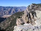
on a more prominent, forested one for a while.) Marked
with occasional cairns, the trail proceeds southwest along the obvious height-of-land,
affording restricted views north. Be sure to head cross-country the short distance
over to the edge (28.7, waypoint 08395) for one of the most spectacular
outlooks along the entire GET. Here, beyond the rugged reef of rock comprising
the upper flanks of Cottonwood Mountain, the range drops dramatically away to
Mud Spring Mesa and Black Rock Canyon. To the left rises the serrated profile
of Pinnacle Ridge, framing the rockbound chaos of Holdout Canyon, partially hidden
from view, while away to the north stands Cobre Grande (Big Copper) Peak. A memorable,
albeit possibly windswept, camp could be made here at the overlook. Trail
66 keeps left of a little gully, avoiding the prominent knoll to the northwest.
Now, at 28.8 (waypoint 08400) it leaves the crest and its scattered semi-burned
stand of ponderosas, and heads southwest on obvious tread toward Cottonwood Canyon.
(The junction with defunct Trail 67 is generally unfindable and of no concern.)
Our trail descends via a sidehill traverse with occasional switchbacks. Campfire
rocks have been arranged to form a windbreak by the final switchback, a small
flat area offering good views out to the Galiuro Mountains and ahead along the
GET toward the Pinalenos. Continue downhill on the rocky trail, as the grade now
steepens a bit. Approaching
the main drainage of Cottonwood Canyon the
trail heads left around a brushy knoll, here leaving the Santa Teresa Wilderness
at a carsonite post, then turns sharply right by a cairn, briefly climbing along
the knoll then descending. Trail 66 now joins the attractive riparian drainage,
which flows seasonally. After crossing back and forth via cairns, at 30.9
the trail descends around a 30-foot-high pour-off, impressive after a good rainstorm.
Before descending, check the pothole-pocked upper portion of the pour-off for
possible good pools. Otherwise leave the trail where it reaches the drainage again
below and head up-canyon to find a pool or two, unless conditions have been droughty.
Back on trail, dabble with the drainage again for a short ways, noting where a
potential camp could be made among the cottonwoods and sycamores, just before
the trail crosses the drainage to climb away up the north bank. The trail now
generally parallels the drainage southwest, ending by a turnout at 31.6,
now outside the Santa Teresa Wilderness. A rough 4WD track - FR 677 - continues
south along the drainage, with good level ground about for pleasant camping. Follow
it to the Coronado National Forest boundary at a brown metal gate (32.1, waypoint
08510). (Sand Tank must be dry or was not noted.) Now
in state land, the eroded 4WD track undulates south among a lush high-desert chaparral
community, away from Cottonwood Canyon, to a junction at 32.5. Here at
a fork, the somewhat wider track of FR 677 turns right (west), while our route
stays straight, now essentially a quad track. (Westbounders continue north
from the junction.) Our route forks again momentarily - take the right fork
here (the two tracks meet up again in a short ways). Now the track turns northeast
and climbs to reach some interesting outcrops, with sweeping views south of the
expansive low country separating the Santa Teresas and Pinalenos. Descend
to cross the drainage of Cottonwood Creek once more. The little-used track briefly
climbs away on the east side of the drainage, then returns to cross it again.
It follows along its west side, somewhat obscurely, then crosses back to the east
side, where it heads laterally away from the main drainage in an area of willows
(34.0, waypoint 08525). After another brief climb-around, the 2-track comes
back to the drainage by a short bedrock pour-off,
unreliable in drier times. However, there are often pools
below the pour-off among sculpted granite boulders, although the tanks and springs
specified on the map aren't really obvious per se. Unfortunately the pools here
tend to be heavily polluted by stock animals. The track remains generally near
the drainage, passing through an open gate at 34.7. Despite the frequent
cattle activity in the area, okay camping prospects can be found among the tall
sycamores in the wide sandy flood plain. After several more crossings of the drainage
a white metal gate comes into view on the west bank, with another on the opposite
side. Here a better road crosses the drainage, entering private property to the
east. (Don't camp near here.) Instead, head over to the west bank and look for
an opening in the fenceline less than 100 feet south of the gate, by a corral,
at 35.3 (waypoint 08530). Pass on through and return to the road you just
crossed, now beyond the drainage of Cottonwood Canyon. (Westbounders reach
the posted white gate along the road and head right to find the unposted opening
in the fence.) The
2WD dirt road heads southwest up a wide wash, then in 0.2 climbs away toward the
south, reaching a junction with 2-lane, graded dirt Klondyke Road at 36.0,
the end of Segment 8 (waypoint 09010, elev. 4800'). This junction is also the
end of the Buford Hill alternate route, which begins in Klondyke and ultimately
follows Klondyke Road eastbound.
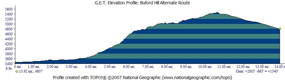
ALTERNATE
ROUTE: BUFORD
HILL
| ELEVATION
PROFILE | 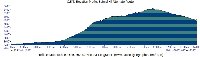 |
This route detours
around the Santa Teresa Wilderness. Beginning in the village of Klondyke, 2.4
mi south of the main GET at mile 5.6, it follows a network of dirt roads, and
in 13.9 miles ends back at the main route along Klondyke Road at the interface
of segments 8 and 9. From
the junction of Klondyke Rd and Fourmile Creek Rd in Klondyke
(2.4 miles south of the main GET at milepoint 0.0 on the Buford Hill alternate
route), proceed southeast on wide, graded 2WD Klondyke Rd to 3.2 (waypoint
08720). Turn left (east) here onto a gated access road through private property,
possibly marked by an adjacent road sign for route 6615. The gate was locked in
2015 by the landowner to prevent vehicle access, however tacit permission has
been granted for GET hikers to continue beyond the gate, but please do not camp,
linger or leave the road while in private property here. (Short-term users should
not park by the gate nor along Klondyke Road.) Pass through another gate at 3.4,
now in state land, where camping is allowed away from developed water sources. Our
4WD road follows Buford Canyon intially, then turns obviously into Road Canyon
at their confluence. At 5.5, it climbs left out of this canyon's wash to
gain a viewful ridge. (Avoid remaining in the wash on the no-go road shown on
the Topo Map Set.) Pass near a couple of stock troughs
on the right, then reach a junction with a more primitive road forking left (north)
at 6.6 (waypoint 08770). (This road leads to a potential camping area in
a quarter mile or so, with far-ranging views.) Our route keeps right on the main
4WD road, and passes through a metal gate at 7.1. Note the prominent hulk
of Buford Hill rising to the north, framed by the serrated profile of Pinnacle
Ridge in the Santa Teresa Wilderness. If only a trail ran along that ridge! Ignore
a lesser road on the left at 7.7 and another at 8.0, the latter
of which descends into South Fork Buford Canyon. Our 4WD road now commences an
extended counter-clockwise bend (another side road heads right at 8.6).
At 9.1 it reaches a windmill with two large cisterns and a trough,
which is now served by a solar array. At 9.4 (waypoint 08820) cross the
small drainage containing Cherry Tree Spring,
a few potential pools of water in the drainage bedrock down-canyon. The secluded
little riparian canyon would allow camping in places. At
the next junction - milepoint 9.7 - turn right by a lone juniper in the
road. Reach a t-intersection with signed, graded FR 677 at 10.5 (waypoint
08840) and turn right. (A
left on FR 677 would lead to the main GET route in 1.1 miles and an option for
accessing Trail 66 into the Santa Teresa Wilderness or potential water in lower
Cottonwood Canyon.) FR
677 proceeds southeast around prominent Oak Butte. En route, pass through a metal
gate, take the left fork at 11.1, and continue on FR 677 to its end at
Klondyke Road (12.7). (Westbounders note that FR 677 is signed "Sand
Tank/Trail 66 4 miles.") Here turn left (east) and follow wide, graded
Klondyke Road 1.2 easy (though shadeless) miles to a rejoining of the main route
at the end of Segment 8 (13.9, waypoint 09010). (Here, marked by a white,
ranch-type metal sign labelled "MC" (or perhaps "Lazy JM")
a lesser dirt track heads north, along with the main route westbound in Segment
8.) 
|