G.E.T.
Guidebook
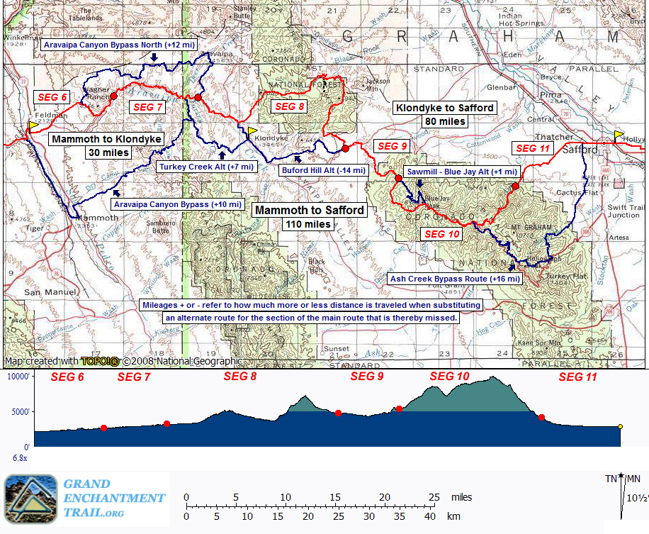
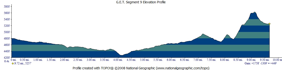
Segment 9: Underwood Canyon 9.8
miles  Guidebook
Home Guidebook
Home
Open
this page for printing
Submit
feedback for this segment
|
Segment
Length | Segment
Status | Season |
|
|
|
9.8
mi. | finalized
& accessible | fall,
winter, spring | | Resources |
| OVERVIEW
MAP |  |
| ELEVATION
PROFILE | 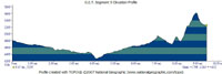 |
G.E.T. Topo Maps 28-29
Water Chart
Image Gallery: Album 3
| Additional
maps:
Coronado
N.F. Safford & Santa Catalina Ranger Districts (USFS)
Land management agency:
Coronado
National Forest Safford Ranger District |
| Beginning
access point | | Ending
access point | |
Off of Klondyke Road.
From Safford, take US 70 west past Pima and turn left on Klondyke Road (signed
Aravaipa Rd). Follow this graded dirt road appx. 18 mi. where a white metal sign
and adjacent road sign "Lazy JM Ranch Rd" indicates a side road at right
(waypoint 09010). This is the start of Segment 9. Follow the dirt side road half
a mile N and park off the road, beside the wash. (Don't park near or block the
gate to the east.) | |
FR 286 at FR 675.
From Safford, take US 70 west to Pima and turn left at sign for Tripp Canyon Road
/ FR 286. Reach an intersection with Patterson Mesa Rd within a half mile and
turn left. FR 286 resumes at right within a quarter mile, marked by metal signs
(brief easement through private land). A large swinging gate soon encountered
should be left as it was found. Proceed southwest on dirt 2WD FR 286. In ~15 miles
from Pima reach a junction with 4WD FR 351. Keep straight on FR 286, heading up
Tripp Canyon. A dirt lot and car camping area is on the right at ~19 mi. from
Pima, at a signed junction with FR 675. (A 4WD vehicle could also get here
via Klondyke Rd by following the directions for the "beginning access point,"
but turning off at FR 351, taking this 4WD road to the junction with FR 286, and
continuing as described above.) | SEGMENT
OVERVIEW The
Santa Teresa and Pinaleño sky islands serve as prominent landmarks, while our
route charts the rolling high desert sea between them in this short but interesting
segment. Eastbound hikers begin in the wide east-draining valley separating the
two ranges and trend south, meandering along adventurous dirt roads, across hackberry-lined
Underwood Wash, and on toward well-ensconced Two Troughs Canyon at road's end.
Here ensues a challenging, mile-long stretch of cross-country travel, as the route
ascends an outlier ridge of the Pinaleño Mountains, before joining descending
track into Tripp Canyon at the base of the range proper. Basic routefinding skills
are recommended for the trackless portion, which climbs an open, grassy slope
at a 20% grade. As one progresses in this segment, the plant community transitions
from spare juniper and mesquite near Klondyke Road, to chaparral and grassland
- as on our climb - and finally to shady pine-oak woodland in the upper reaches
of Tripp Canyon, a noteworthy change given the segment's minimal net elevation
gain. Surface
water here is generally limited to a single, impermanent spring and a few stock
sources, one of which (Holdout Canyon Tank) features a solar-powered well. In
addition, a fairly reliable source is located in the main drainage of Tripp Canyon,
a short walk beyond the end of this segment, in Segment 10, near the junctions
of FR 286 (Tripp Canyon Rd) and FR 675. And speaking of moisture, if you're heading
eastbound in early spring of a high mountain snow year, then you may have already
noted the white stuff high atop the Pinaleños ahead. Should you opt to avoid the
range altogether, one possible though not particularly salient detour follows
Tripp Canyon Road east about 19 miles to US 70 at Pima, then south to Safford
(the above Ending Access Point directions in reverse).
ROUTE
DETAILS This
segment begins where Klondyke Road meets a lesser 2WD dirt road, the junction
marked by a white, metal, symbolic ranch-type sign and adjacent road sign along
Klondyke Rd indicating Lazy JM Ranch (waypoint 09010, elev.4800') Proceed northeast
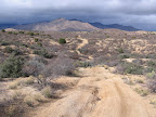
along wide, graded Klondyke Rd. Although still far-flung by modern standards,
Klondyke Road is nonetheless the main travel route between US 70 north of Safford
and the Klondyke area. As such, it's quite possible you'll see an occasional vehicle
along this stretch, particularly on weekends during hunting season. Within
100 yards of the segment's start, pass a lesser dirt road that heads right (south),
just opposite a track that returns to the JM Ranch road. Farther along, at 0.7
of a mile, FR 672 takes off at right, the graded dirt road marked prominently
at the junction by a yellow roadsign. An adventurous hiker could follow this road
for less than 0.2 mi., where it is crossed by Hackberry Wash, and follow the secluded
drainage east, cross-country to Register Tank along the main route ahead, but
the drainage is occasionally choked with low-hanging junipers. Otherwise, continue
east on Klondyke Road. At
1.2 a road heads left, entering private property en route to Upper Falls
Spring environs (reliability unknown). Finally, leave Klondyke Road at 1.9
(waypoint 09020) by turning right (south) onto a narrow, unsigned 4WD track. (This
junction is located just beyond a little turn-out on the right, and before Klondyke
Rd begins a descent into Cottonwood Canyon.) The
track bends around toward the southwest, with the low knob of Juan Hill just to
the east, and soon crosses the impoundment of Register
Tank, an earthen stock pond that seems to hold some water except in
particularly dry times. Beyond
the tank the rough 4WD turns south, coming to a fork at 2.4 (waypoint 09025).
Take the left option (southeast), remaining on the somewhat better track. The
landscape of scattered juniper, live oak, and agave is sufficiently flat for camping
in the vicinity of the junction. At 3.3, the road jogs briefly west by
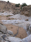
a fenceline, then crosses the wide sandy wash of Water Canyon. Just north of the
wash a wide opening in the fence leads to a dry impoundment and offers access
to Indian Spring farther down the drainage.
To reach it, head around the left side of the impoundment and back down into the
main drainage. Continue to an area of bedrock in the wash, reached in 0.2 mi.
Here, below a negotiable pour-off, you may find pools and sometimes flowing water.
The likelihood of encountering water again diminishes soon beyond the bedrock
portion, 0.1 mi. farther along, so don't spend too much time scouting here if
the rock potholes happen to be dry. Now
our road leaves Water Canyon, dips sharply into a narrow drainage just beyond,
then passes a 2-track on the left, which despite appearances does not go
to Indian Spring. Goat Peak, to the north in the Santa Teresas, slinks ever farther
away on the skyline as our rough 4WD road undulates on to Underwood Wash, at 4.0.
Turn left (east) down the wash, where shady camping is possible among the bordering
hackberries, then in 100 yards follow the road out of the main wash on its opposite
side. (Westbounders turn left up the wash and look for the road as it leaves
at right.) Climb
to an obvious 3-way junction at 4.8 (waypoint 09030). For those genuinely
disinterested in the steep and somewhat brushy cross-country travel required farther
along the main route, a workable detour heads left here - the black dashed line
on the map set. This detour, located entirely on dirt roads, passes a couple of
potential water sources, and returns to the route at the end of the segment in
11.6 miles, thus making it 6.8 miles longer than the main route. The
main route turns right on the road at 4.8, reaching a corral by a wire
gate at 5.3. The 4WD road soon resumes its gentle southward climb, increasingly
among granite outcrops not unlike those encountered in the Santa Teresa Mountains.
A pair of metal gates appears by a road junction at 6.0 - pass through
the one on the left, remaining on the wider road. The gates mark our return to
Coronado National Forest land (in spite of any ranch-type signage you might find
to the contrary). Ahead, appropriately-named Brushy Tank is hardly discernable
now, more dry brush than stock tank. The grade steepens ahead as the road trends
east to top a saddle at 7.2. A lesser track (not ours) heads south along
the saddle, a soon-murderously steep swath that dead-ends at an old quarry. Continuing
east from the saddle, pass the small earthen bowl of Deer
Tank, sometimes holding good water in wetter times. As the road nears
the bottom of the next descent, at 7.7, a large metal tank appears at left
alongside a trough with float valve. Previously fed by a gas-powered pump, a solar
array now provides more reliable water to both. (This source is unofficially called
Holdout Canyon Tank on the water chart, not
to be confused with an earthen pond of unknown reliability, farther down the drainage
as shown on the map. And by the way, plan not to camp in this vicinity,
as it seems to be very popular with the bovine crowd whenever water is present.)
The elevation lost on the descent is recovered in short order on the road's climb
to the next saddle, reached at 8.1 (waypoint 09110). Long-abandoned corral
workings creak in the wind, amplifying the solitude. Perhaps fittingly, the road
ends here, petering out among the high-desert grasses just south of the corral.
The goal now
is to reach the crest of the long ridge to the southeast, and the cross-country
route to that crest is entirely visible here, so get your bearings before proceeding.
(See illustration.)
First note the high point along the ridge, labelled Dick Peak (el. 6250'), a survey
benchmark on the topo map. To its right along the ridge is a broad saddle with
two separate low points, left and right. Your destination is the low point to
the right, the lower of the two. To reach it, you'll follow the main ascending
ridge that "supports" the saddle, the slope with a prominent hump about
half-way up it. From
the old corral, continue east downhill into Two Troughs Canyon, keeping left of
a minor tributary drainage en route. Reach small, earthen, normally dry Pipeline
Tank in the main drainage (waypoint 09120). Now cut across the little side drainage
coming in from the south, and start up the rise beyond it. You'll follow this
slope south-southeast all the way up to the crest, 850 feet above. Navigation
is straightforward on the open slope, and the vegetation is initially sparse.
Keep near the backbone of the grade approaching the hump, scouted earlier, as
the sides are steep with outcrops. An old metal post or two just beyond the hump
suggest evidence of a former pack route along this ridge, and the path of least
resistance beyond certainly seems to hint at relict use of this corridor. The
upper part of the climb does become brushy, and care must be taken to avoid the
occasional agave and catclaw. Nearing the crest (but not too soon), angle your
climb over to the right, more at contour now, aiming for the low point above the
drainage there. A fenceline gate and old, dry stock trough welcome you to the
little pass and the end of the cross-country climb (9.2, waypoint 09130,
elev. 5624'). Pause to admire the view of distant Pinnacle Ridge behind you in
the Santa Teresas, and, deeply forested, the dark prominence of Blue Jay Ridge
high in the Pinaleños ahead. (Westbounders, passing through the gate
at the notch in the ridge at 9.2, proceed north at contour out along the hillside
to your right (the right side of the drainage that drops away here). Remain generally
at contour as the vague trail peters out, and work your way round the hillside
to the fall line along the buttressing ridge, then descend this directly, heading
over a prominent hump about half way down. Veer left (west) near the bottom of
the ridge to enter the drainage of Two Troughs Canyon near Pipeline Tank (waypoint
09120). Proceed west up Two Troughs Canyon a short ways, then climb out on its
right bank, heading west up the slope to the saddle and corral at 8.1(waypoint
09110).) Start
down the other side of the ridge on a vague stock path. The rough path soon jogs
right to descend along the west side of the drainage, steeply at times. Ignore
occasional diverging tracks that veer well away to the right, or that drop into
the drainage bottom itself. The path becomes a 2-track road at a turnout (waypoint
09140) and continues down the slope, soon passing a small, viewful campsite. More
camping is available ahead, where the track heads through a broad clearing at
the base of the slope. A side track to the east here heads over to an historic
grave plot atop a low rise. The headstone or memorial is set in pure quartz stone
fragments from the surrounding area and is worth a look. Our unnamed 2-track now
crosses the pinyon & juniper-lined drainage of Tripp Canyon, where it reaches
FR 675 (9.8, waypoint 09160) at segment's end. Additional "car camping"
sites persist along the braided dirt track of FR 675 for some distance to the
east, many of them well shaded. Water often flows not far to the east in the main
drainage of Tripp Canyon, just beyond the junction of FR 675 and FR
286 (waypoint 09155), where you may also find water in a stock trough located
within a corral at the far end of a large dirt parking area. (Refer
to the FR 286 Alternate Route description in Segment 10.)
|