G.E.T.
Guidebook
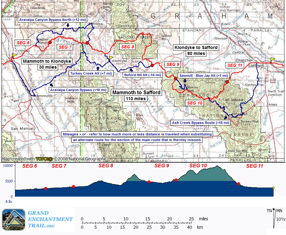
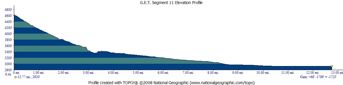
Segment 11: Gila Valley South 12.8
miles  Guidebook
Home Guidebook
Home
Open
this page for printing
Submit
feedback for this segment
|
Segment
Length | Segment
Status | Season |
|
|
|
12.8
mi. | finalized
& accessible | fall,
winter, spring | | Resources |
| OVERVIEW
MAP | 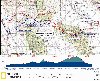 |
| ELEVATION
PROFILE |  |
G.E.T. Topo Maps 32-34
Town Guide: Safford
Water Chart
Image Gallery: Album 3
| Additional
maps:
Safford
1:100K Topographic (BLM)
Land management agency:
BLM
Safford Field Office
Coronado
National Forest Safford Ranger District
|
| Beginning
access point | | Ending
access point | |
FR 307 at Ash Creek Trailhead.
From Safford, follow US 70 west to Pima, then take Main St south to its end.
Turn right on Cottonwood Rd, then left on dirt 2WD Cluff Ranch Rd. Reach Cluff
Ranch wildlife management area in 4 mi, where 2WD vehicles should park (~5 mi
before the actual Beginning Access Point for this segment). Suitable high-clearance
vehicles such as Jeeps may continue on Cluff Ranch Rd. Keep left at the fork by
main entrance to Cluff Ranch, then turn left at a 3-way junction onto signed Berry
Patch Rd. Stay on the main road, which becomes Ash Creek Rd (FR 307) and follows
an old water pipeline. The rough rocky road, which crosses Ash Creek three times,
ends in ~4 mi from Berry Patch Rd jct, at a turnout nearby the trailhead, which
is signed with a metal post. (The final 1.8 mi of this approach is concurrent
with the route of the GET in Segment 11.) | |
US 70 at 8th St &
Hollywood Rd. The GET crosses US 70 here, a half mile east of downtown Safford.
Free, long-term parking may be available in town; inquire at the Chamber of Commerce
office on US 70 between 8th Ave and 14th Ave (with a large parking lot nearby),
or at the USFS/BLM office on 14th Ave at 8th St. | SEGMENT
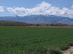
OVERVIEW Our
route descends the eastern foothills of the Pinaleño Mountains to join the broad
Gila Valley on the outskirts of Safford. Last encountered in Segment 3, the Gila
River here is truly a ribbon of life in this otherwise arid valley of greasewood
and mesquite. Aided by a mild, Sonoran-Chihuahuan desert climate, the Gila's reliable
flow permits the growing of cotton, the staple commodity of Safford's agricultural
economy. You'll pass acres of the fluffy white stuff toward the end of this segment
as well as in Segment 12; much of it is grown well away from the river thanks
to an elaborate network of aqueducts. (The main GET route doesn't actually cross
the Gila until the next segment.) Hikers
begin alongside the riparian canyon of lower Ash Creek (via FR 307, the vehicle
approach to the trailhead), then strike off on an adventurous cross-country shortcut
toward Mud Springs Knoll, an intriguing landmark where the foothills of Mount
Graham meet the open desert. Dry plains and low mesas, dotted with creosote bush
and uninhabited, now serve us our companions for several miles of dirt road walking
toward the rural outskirts of Thatcher and Safford, Joining 8th Street, our route
then heads right on through the bustle of town, a natural stopover for hikers,
with numerous services located nearby along US 70, about a quarter mile away.
Don't be surprised if you're greeted with the occasional smile and wave from passing
motorists; Safford's townfolk are accustomed to seeing self-propelled travelers
about, thanks to the Southern Tier bicycle route that comes through town. Water
is available only near the start and end of this segment, at Ash Creek as well
as (small, fragile) Mud Spring, and in Thatcher / Safford, respectively. Quiet
camping opportunities present themselves here and there in the first half of this
terrain, particularly around Mud Springs Knoll. As
a noteworthy aside, a bit north of the GET near the start of this segment lies
Cluff Ranch wildlife area. Those approaching this segment by vehicle (as well
as mountain bikers and equestrians disinterested in this segment's brief cross-country
travel and game for improvising a longer way into Safford) pass by Cluff Ranch
along Ash Creek Road, a couple of miles north of the GET route. Administered by
the Arizona Department of Game & Fish, the wildlife area supports a variety
of upland bird and small game species, as well as a healthy population of white-tailed
deer. Scattered small ponds in the area, fed by Ash Creek, attract migratory waterfowl.
Fishing is permitted here, as is seasonal hunting, while the surrounding groves
of cottonwoods and willows are inviting to all. Developed water is available,
as is a short network of trails that wind through the property.
ROUTE
DETAILS From
the metal trail sign at the northern terminus of Ash Creek Trail (waypoint 10370,
elev. 4672'), travel northeast on Ash Creek Road (FR 307). The narrow, rocky 4WD
track parallels lower Ash Creek in its riparian
corridor, crossing a cattle guard at 0.8 of a mile, near where it fords
the creek itself. An old metal pipeline, used to bring water from the perennially-flowing
reaches of Ash Creek to reservoirs in the valley below, follows the road as well.
The massive, rumpled folds of the Pinaleños slowly recede to the south
and west as the road comes to a metal gate at 1.6. Note the low hillside
immediately east; actually this is the edge of a broad mesa that slopes gradually
away toward the northeast (toward Safford). The suggested route of the GET leaves
the road at around 1.8 (waypoint 11030) to follow the mesa top - just before
the road jogs left, leave it, picking a line through the scattered mesquite to
surmount the 50 foot rise. (If you reach a forest service sign along Ash Creek
Road, or come to another cattle guard, then you passed the x-c turnoff. Also note
a portion of the old metal pipeline sometimes drips audibly into a little
pool at roadside, right near the suggested point of departure.) From
the scenic top of the mesa near 1.8, the goal is to reach Mud Springs Knoll
environs a little over a mile away, where a 4WD road picks up. The lone knoll
itself is visible off to the northeast, a prominent conical hill beyond the mesa.
The most efficient route seems to be to keep as close as possible to the western
edge of the mesa (keeping the drop just off to eastbounder's left); doing so minimizes
exposure to low mesquite and other brush, while also providing a handrail that
will set you up for the final drop off the mesa toward the 4WD. (Straying too
far inward from the mesa's edge risks marooning you as the mesa becomes dissected
by several steep drainages en route.) The x-c route is actually very straightforward
when executed as described. And the views of Ash Creek Canyon and the majestic
panorama of Mount Graham, to say nothing of the pioneering sense of isolation,
add considerably to the experience. The sinuous edge of the mesa bends more easterly
approaching waypoint 11040, where a narrow drainage cuts in the mesa, dropping
north. This is our ticket off the mesa - either head directly down the rocky drainage
or work your way around to the other side and head down the adjacent slope. About
3/4 of the way down you may note a game path heading east, and can take this over
to waypoint 11050 at a 4WD turnout (MP 3.1). Mud
Spring is located here, a small seep and pool at the base of the slope.
Surprisingly this fragile desert source appears to be somewhat reliable (but don't
count on it being deep enough to collect from). (Westbounders,
to reach the top of the mesa from Mud Spring head west beyond the road onto a
game path. Follow the path along the base of the slope until it essentially peters
out then head x-c up the drainage ahead on your left, or up the slope just before
it. Once atop the mesa, follow the north / western edge of the mesa as a handrail,
trending southwest for a bit over a mile. When Ash Creek Road comes into view
just below you, descend the final 50 feet off the mesa to join it, such as at
waypoint 11030.) From
Mud Spring at 3.1 join the 4WD road as it heads downhill, then ignore a
left fork and continue east on the 4WD (westbounders take the left fork, heading
uphill). Keep straight at a t-junction with another road just west of an old
corral. The corral could make for a possible camp, or for more seclusion find
a way over to mapped Mud Springs Tank, which is usually dry and offers a few shade
trees around its perimeter. The GET keeps south of the corral on the eastbound
4WD, which crosses a wash then climbs northeast. Here the 4WD is eroded and forks
somewhat confusingly. Keep northeast. The road improves as it levels off just
south of Mud Springs Knoll. (Westbounders take the left fork as the corral
area becomes visible off to the west, and head down to it.) The 4WD now trends
east among creosote bushes and other hardy desert scrub, offering pleasant and
generally quiet walking. It crosses several washes, then climbs out to a 4WD junction
at waypoint 11060. Turn left here, northeast, to stay on the main track. Pass
through a wire gate at around 5.0. The 4WD then terminates at an unsigned
junction with graded dirt Frye Mesa Road (FR 103) at 5.3 (waypoint 11080).
(Westbounders be on the lookout for the 4WD junction on your right; although
unsigned it's the only such junction in the general vicinity; the waypoints as
well as a gate along the 4WD at 5.0 offer confirmation.) Turning
left (northeast) onto Frye Mesa Road, our route now continues uneventfully through
open terrain across state land for several miles. At length the road bends due
east, passes a state lands information board, and then terminates at paved Reay
Lane on the outskirts of Thatcher at 8.5 (waypoint 11090). (Helpful
tip: If you need to visit the bushes, consider doing so before reaching this junction,
as the rest of the route into Safford is developed. Alternatively you could head
north from around 8.8 via a cemetery and Stadium Ave a short distance to a public
park with water and toilets, or else (if need be) continue the better
part of a mile to Eastern Arizona College
in Thatcher for water and restrooms, then follow the railroad grade southeast
to rejoin the main route at 10.2 - see the topo mapset for details.) From
8.5 the easiest way forward is to cross over Reay Lane to join a gravel road -
apparently a public right-of-way - that runs by a pair of modular storage buildings.
The gravel road soon ends at a junction with 8th Street, opposite a town cemetery.
Turn right to follow 8th St east. The GET remains on this road all the way through
Safford to the end of this segment. Initially rural-residential in character,
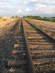
8th Street crosses 1st Avenue at 9.7, then parallels the Arizona Eastern
railroad grade beyond 10.2, where cotton fields dominate the foreground
for a spell, lending a bucolic air. The railroad corridor now affords a vehicle-free
swath at roadside for much of the way through town (the tracks do carry an occasional
train, so be sure to stay off to one side). Agriculture
soon gives way to Safford's business district at 20th Ave (10.7). You can
turn left (north) here to reach US 70 where a majority of the town's services
are located. And you can easily rejoin the GET farther ahead on your way out of
town. Otherwise, continue along the railroad grade swath. Cross
14th Ave at 11.2; the US Forest Service and BLM district offices are housed
in a single complex on the northeast corner here; you might consider putting in
a good word on your way by. (Westbounders can also pick up their BLM Aravaipa
Canyon Wilderness permits here.) Pass a convenience
store with Subway sandwich shop at the intersection of 8th St with
8th Ave (11.7), and continue straight on 8th St. On the opposite side of
the road is the Safford public library, with internet access, public restrooms,
and a water fountain located inside. After
3 more intersections reach 5th Ave, with the Safford post office located about
a quarter mile north at the junction with US 70. 8th Street next leads past an
IGA supermarket, then crosses US 191 (signed
First Ave) at 12.2 - be careful crossing traffic here. The segment ends
a half mile ahead at the junction of 8th Street and US 70 (12.8, waypoint
11130, elev. 2920'), where the railroad grade bends away to the southeast. (Westbounders,
join 8th St heading west and follow the adjacent railroad grade/swath, away from
traffic.) |