G.E.T.
Guidebook
Segment 3: White Canyon Wilderness 30.8
miles  Guidebook
Home Guidebook
Home
Open
this page for printing
Submit
feedback for this segment
|
Segment
Length | Segment
Status | Season |
|
|
|
30.8
mi. | finalized
& accessible | fall,
winter, spring | | Resources |
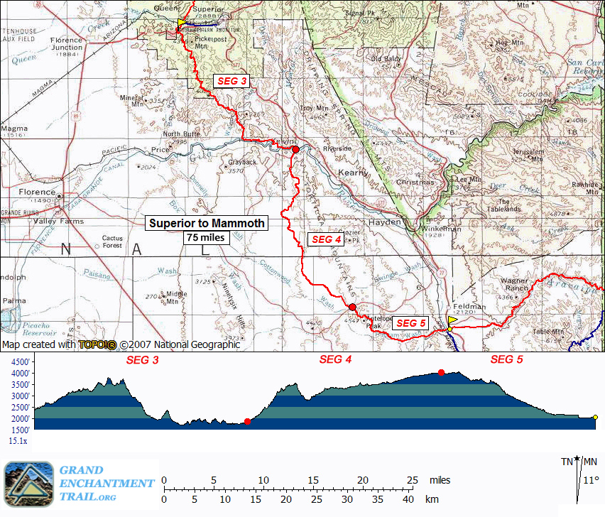
| OVERVIEW
MAP | 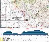 |
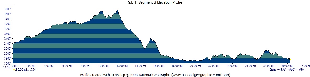
| ELEVATION
PROFILE | 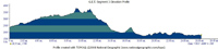 |
G.E.T. Topo Maps 6-9
Town Guide: Superior
Water Chart
Image Gallery: Album 2
| Additional
maps:
Tonto
National Forest (USFS)
Mesa 1:100K Quad (BLM)
Land
managing agency: Tonto N.F. Globe Ranger District
BLM Tucson Field Office |
| Beginning
access point | | Ending
access point | |
Picketpost Trailhead
at Forest Route 310.
Picketpost Trailhead is accessible by passenger car. ~4.5 miles west of the town
of Superior, or 0.4 mi east of marked highway milepoint 221, turn south off US
60 onto FR 231. (Formerly obscure, the turnoff has now been signed "Picketpost
Trailhead" by the Forest Service.) Follow dirt FR 231 0.3 mi., passing Picketpost
Windmill, to a junction and turn left, now on FR 310. Take this road 0.7 mi. to
its end at Picketpost Trailhead, with ample parking. | |
Florence-Kelvin Road
at Kelvin-Riverside bridge.
Take AZ 177 south from Superior or north from Winkelman. Turn off at sign for
the village of Kelvin onto Florence-Kelvin Road. Follow this paved 2-lane road
1.3 miles, through Kelvin (no services) to Kelvin-Riverside bridge over the Gila
River. A dirt turnout is south of the bridge at a junction with Riverside Rd on
the left. Alternate parking: If accessing GET / AZT singletrack in Segment
3, or for longer term parking, instead follow graded dirt Centurian Lane west
(from the north end of Kelvin-Riverside bridge). Continue 0.5 mi. on the main
road to reach a parking area on the left. 2011-built Arizona Trail heads west
into Segment 3; the segment continues eastbound along the road you just followed. |
SEGMENT
OVERVIEW Relatively
small and little-known, yet big on solitude and Sonoran desert charm, the BLM
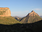
White Canyon Wilderness is the centerpiece of this adventurous segment. Expect
to be surprised and impressed with the Superstition-esque landscapes preserved
in this parcel of wildland, but your inspiration here must first be earned. For
the hiking is sometimes rugged and primitive, particularly in the Wilderness area
itself. The terrain also offers up a healthy dose of elevation gain and loss,
with limited access to reliable water. In
late 2011 the final miles of the Arizona Trail between Mexico and Utah were completed
above the Gila River at the southern edge of the White Canyon area, where a small
ceremony was held and a commemorative survey marker installed. The event was a
significant milestone in the evolution of that trail, and tacitly for the GET
as well. The GET has, and continues to, benefit from ongoing Arizona Trail construction
and maintenance, and so it does in this segment. However, the GET has never been
beholden to the AZT, and sometimes the two routes might diverge if it's in the
best interest of either route to do so. In fact, while much of GET Segment 3 follows
the route of the Arizona Trail, a portion of it now goes its own way, in spite
of the availability of newly-built AZT trail miles. A further explanation is probably
in order. Prior
to the completion of the Arizona Trail in this area, both the GET and the interim
Arizona Trail followed the same route throughout. Now, the two routes diverge
partway through GET Segment 3, specifically between milepoint 10.4 and 19.5. Here,
the suggested route of the GET remains generally with the former, "interim" AZ
Trail route in this 9-mile stretch, despite it being considerably more primitive
than the newly-completed AZ Trail and also involving some 2-track and wash / drainage
travel. (The new AZT is located primarily on singletrack trail, wide and clear.)
The reasons for keeping the GET along the old route are several. One is that,
as a matter of practicality, the old route offers access to the only near sure-bet
water in this entire segment - ranching sources located in Walnut Canyon, in combination
with natural surface flow and pools in this area. (The new AZT can be dry, save
for the more reliable Gila River which to one extent or another is polluted by
agricultural and mining runoff here.) Also, the old route is some 5 miles shorter
in length, and while expediency is not the overarching goal of the GET's layout,
the newly-built AZ Trail is both longer AND drier, compounding concerns that are
avoided by taking the old route. Finally, from a purely philosophical standpoint,
the old route runs through the BLM-administered White Canyon Wilderness area,
which the finalized AZ Trail avoids in order to legally accommodate bicycle traffic.
Both routes are very scenic, to be sure, but the GET would be remiss if it didn't
avail itself of Congressionally-designated Wilderness wherever such an area remains
so readily available and, in many ways, more accommodating than the alternative.
In any event, both routes are shown on the mapset, and of course either route
is available to suit one's particular interest. (The two routes together would
make for an excellent loop trip in conjunction with some out-and-back miles between
trailheads at either end of the segment.) Elsewhere
in this segment, the GET piggybacks enthusiastically onto the Arizona Trail, including
many miles of supremely scenic, well-engineered singletrack that is, to be sure,
a dream to travel, be it on foot, by horse, or on a bicycle. Together, the two
routes pass the Arizona Trail completion marker set trustily into the desert dirt
above the banks of the Gila River, a testament to progress. Just be sure to pack
along plenty of water, whichever way you go to get here. (As
mentioned, potable water - of which the long-journeying Gila here is generally
not - is often scarce in Segment 3, but thankfully there is likely good water
to be found in Walnut Canyon approximately halfway along. In addition, the community
of Kelvin, half a mile north of the route at the segment's eastern end, has water
available. See the Water Chart for current info.)
ROUTE
DETAILS Picketpost
Trailhead lacks water, and the nearest certain source is nearly 17 miles away
in the middle of this segment. (See comments at the end of Chapter 2 for information
on potential off-route sources within range of Picketpost Trailhead.) Begin
from the trailhead following constructed Arizona Trail singletrack (the left-most
option; waypoint 03010; not the dirt road). The trail dips to cross several branches
of Alamo Canyon's wash, then begins a meandering contour along the bajada separating
the wash and Picketpost Mountain. A remnant volcanic feature, Picketpost is comprised
of thick deposits of tuff, or solidified ash. At 0.5 of a mile, the trail
crosses an old jeep track. (The jeep track heads southeast toward a small mining
adit and the start of a class 3 hiking route to Picketpost Mountain's summit,
an adventurous side trip.) Arizona Trail tread continues to contour through several
side drainages amidst lush Sonoran desert vegetation. Eventually the trail returns
to the main wash, parallels it briefly, climbs somewhat away again, then returns.
Here, at 2.4 (waypoint 03065) constructed trail heads sharply left. (A
former "detour route" of the nascent Arizona Trail in this area once
continued up Alamo Canyon's wash, passing a solar-pump-fed
trough and pond in 0.6 of a mile, as described on the Water Chart -
a worthwhile side-hike given the often droughty nature of this segment, with camping
prospects en route. This source has been reported on / functional in recent years,
but don't count on it. And if you do find water here, by all means tank up with
enough to carry you to Walnut Canyon around MP 17.) Proceed
southeast, following the trail up alongside a fork of Alamo Canyon. At 3.2,
the trail bends south, climbing and contouring along a minor ridge. Dipping to
cross a drainage at 4.2, a well-engineered climb then rounds a hillside
flank. Here the trail resumes its southern tack on a secluded contour. Upon gaining
a minor saddle, the trail traverses and switchbacks around the heads of several
east-draining washes; in wetter times, a large pool or
two might be visible upon approaching the drainage at 6.1,
located within 100 yards or so below the trail crossing (and likewise for the
next drainage crossing south - but don't count on either!). A meandering descent
finally leads to dirt, 4WD Forest Route 4 at 7.3 (waypoint 03140). A public
water cache box is located just to the north along the road. Installed
by the Arizona Trail Association, the metal box is more likely to be stocked in
springtime, such as by an AZT passage steward, but don't count on it. If this
is dry, you can check out unreliable Trough Springs
(waypoint 03130) by heading north along this road a short ways to the first drainage
crossing and turn left down the rocky wash. Small pools are occasionally found
near the road, or continue to a junction of drainages and head left up the other
one in search of a pipe-fed spring that feeds into a large cement trough. This
source has become less dependable in recent years and may be defunct - see the
Water Chart for the most recent status. From
7.3, singletrack continues east, directly across FR 4. It follows alongside
a wash initially, then just before a drainge fork the trail crosses the wash to
remain on its eastern side. At 8.8 the trail climbs out of the canyon bottom,
slabbing south and east to gain a scenic pass, before descending into another
prominent drainage at 10.4. (The seep
nearby to the west shown on the topo map is unreliable, though you may find a
few small wet spots in the drainage here and there following recent rain. Another
possibility is a stock trough located southwest of the junction at 10.4, a short
distance away above the banks of the wash.) Constructed
singletrack continues across the wash. This is the section of Arizona Trail
that circumvents the White Canyon Wilderness. The GET diverges from the AZT here
by turning left down the wash. The two routes resume at GET milepoint 19.5, with
the AZT taking 5.2 miles longer to reach that point (~14 miles all told instead
of ~9 for the GET). Water along the new AZT is potentially limited to the polluted
Gila River, while the GET takes hikers by proven-reliable Walnut Canyon about
half-way along. Following
the GET route down the wash, reach
a cairned junction with a larger wash (waypoint 03180) and turn right. (Westbound
hikers look carefully for the cairn where you leave the larger wash to the left.
A tenth of a mile later, turn right onto constructed Arizona Trail singletrack.)
In 100 ft, by a
wooden Arizona Trail sign marking the former interim route of that trail, turn
left out of the wash onto foot trail. The primitive, little-used trail contours
east among lush desert vegetation, dipping awkwardly into several brushy gullies,
then climbs to a viewful saddle at 11.7. A good dry camp could be made
here. Do not be discouraged by the overgrown character of the trail to this
point, as conditions continue to improve in this regard continuing east. Pass
through a gate on the saddle and descend to another saddle, potentially still
marked by an Arizona Trail-branded carsonite post. Grand views extend down the
colorful canyon to the south, its striated walls looking very much like sandstone
but composed primarily of welded volcanic tuff. Here the trail turns south, descending
more steeply toward the boundary of BLM White Canyon Wilderness, as marked by
another post, where it leaves the Tonto National Forest. The faint trail, marked
by small cairns, approaches a third (and lowest) saddle at 12.1 (waypoint
03200) (Westbounders: from the saddle, note the prominent "Hole in the
Rock" feature just north, toward which the trail climbs, passing immediately
to the left of the outcrop.)
From the saddle the trail turns abruptly right (south), following cairns into
the head of a prominent south-facing canyon, first over bedrock a short distance,
then on rough trail which traverses gradually downhill along the canyon's east
side. Look carefully for small, improvised cairns in this section. The trail dips
awkwardly across a couple of side gullies, then crosses the canyon's main wash
at 12.9. Just beyond it meets up with an old 2-track road junction (waypoint
03210) which it joins, continuing downhill toward the south (ignore the right
fork at the junction; westbounders likewise continue straight then immediately
cross the wash at 12.9). The old road, long closed to vehicles, soon re-crosses
the main drainage, then heads around the base of the prominent escarpment dividing
our unnamed canyon and the Wilderness area's namesake White Canyon, Eventually
our track turns due south, descending more steeply to a junction at the wilderness
boundary at 14.7 (waypoint 03230). Here the GET meets wide dirt Battle
Axe Road, the main public access route to and from White Canyon Wilderness. The
road, potentially 4WD high-clearance in places, leads 5 miles east to Highway
177, along the way passing the scenic junction of White Canyon and Walnut Canyon.
However as of late 2014 there is no longer public access down Walnut Canyon from
this area, a portion of which happens to be owned by a mining company. As such,
the GET now detours around the private lands, reaching Walnut Canyon farther south,
as follows. Turn
right (south) from 14.7, following eponymous Battle Axe Road uphill along the
western side of dramatic Battle Axe Butte. (Westbounders: leave this road to
the left at a carsonite post, heading over a low berm intended to deter motorized
vehicles, here entering BLM White Canyon Wilderness.) The
road reaches a height-of-land from which a secondary track forks left and eventually
dead-ends. Ignore this track, instead keeping with the main, wide road,
which now descends to another, more prominent t-junction at 15.5. Here,
turn left (east) onto the other road, primarily 4WD in character as it continues
beyond a wire gate (waypoint 03241), then soon beginning a sharp descent into
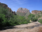
picturesque Walnut Canyon. The Sonoran desert scenery on display remains as impressive
as ever. Our
route leaves the 4WD road where it meets the prominent wash of Walnut Canyon (16.7,
waypoint 03242) to begin a section of cross-country drainage travel en route to
the Walnut Canyon Narrows and likely water. Before committing to this route, though,
it's probably a good idea to first head up-canyon a short ways to an area where
water has also historically been available, just to ensure that no opportunity
to find critical water is missed. Walnut Canyon typically has some flow
and/or pools within 0.3 mile north of the road crossing. As of Fall
2014 a pair of blue plastic troughs were also
present in this area (waypoint 03242), pipe-fed from an artesian well located
farther up-canyon on posted land. The troughs, somewhat hidden from view, are
located on the east side of the canyon bottom, above the banks of the wash proper,
and may be easiest to reach by veering out of the wash perhaps 100 yards to the
south of their location and heading "overland" to the above waypoint. Back
at the road crossing of Walnut Canyon at 16.7, our route leaves the road and heads
south down the wash, which gradually becomes more constricted and slickrock-like
on approach to the aptly-named Walnut Canyon Narrows, a small but truly outstanding
area with sheer, weathered cliffs, lush riparian vegetation, and - likely quite
often - good tinajas, or rockbound pools.
This section of Walnut Canyon is part of a Fall 2014 relo, so more should be known
of its reliability as a water source in future seasons. In wetter times it may
take some effort to keep the feet dry here, manuevering among the bouldery banks
or simply sloshing through pools, savoring the rare ambience. As the canyon bends
south beyond 17.1, a final area of pools is sometimes fed from a cliff
seep, which can be impressive to behold after good rains. Beyond
the Narrows, our cross-country canyon by and by becomes more easygoing, affording
the opportunity to walk and gawk, in particular at the unusual, highly-weathered
ridgeline and bajada on display to our west. A camp could be made in the increasingly
open canyon bottom as well. At length a jeep track joins the sandy wash (18.2,
waypoint 03246) and we continue with it to a junction at 19.5 (waypoint
03247). Here the GET rejoins the Arizona Trail, which crosses the wash from west
to east. To the west of this junction the AZT exists as constructed singletrack
trail, while eastward it joins the jeep track we've been following since 18.2.
(First though, you may have the inclination to continue down the wash another
quarter mile to the Gila River, surrounded by shady willows and tamarisks. A good
camp could be made here as well, though the long-journeying river best serves
as ambience - or perhaps for a swim or shower - and not for drinking or cooking
purposes.) From
19.5, follow the AZ Trail-branded jeep track eastward, out of the wash. (Westbounders,
upon reaching the wide, two-channelled wash at 19.5, turn right (north) up the
second channel to remain with the GET and jeep track, or else continue west across
the wash to adhere to the finalized Arizona Trail layout which avoids the White
Canyon Wilderness and the GET's more reliable water en route.) The jeep track
now heads overland, offering good eastward outlooks toward the long north-south
ridgeline known as The Spine, and occasionally dipping to cross a sandy wash.
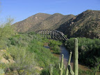
The Gila River runs nearby for a spell, just beyond a wire fence, audible but
well-hidden in its tunnel of tamarisk bushes. Our jeep track splits at another
wash crossing, where we follow AZ Trail signs across the wash to 20.8 (waypoint
03248). Here an Arizona Trail Association-installed ATV barrier protects the trail
corridor beyond for the benefit of hikers, cyclists, and equestrians. At
21.0 (waypoint 03250), foot trail leaves the fenceline, heading northeast
and soon passing a large cairn. The trail meanders along a scenic south-facing
slope above the river, which soon enters a "narrows" that may have been
created by the river's downcutting into a rising granite intrusion. In any case,
the terrain soon becomes exceptionally bouldery, yet the trail has been built
to a very high standard, a pleasure to walk. The
trail crosses several steep side drainages of The Spine, generally on a well-graded
contour. It then crosses a wide sandy wash via cairns at 24.4. (The tree-lined
banks of the Gila River lie 150 yards south in this wash, perhaps the only good
shade for several miles in either direction.) The trail then contours over to
a powerline service 2-track road, reaching it at 25.2 (waypoint 03270)
and turning right onto it just briefly before climbing away at left, again as
singletrack. After gaining the crest of a minor ridge, the trail descends eastward
to cross a prominent wash at 25.8 (waypoint 03350), then turns
southeast, undulating in and out of minor drainages amidst lush Sonoran desert
vegetation. At 27.0 (waypoint 03400), the trail reaches the northwest
side of a fence corner and turns east. The terrain soon steepens as the contouring
trail nears the Gila River, paralleling its north bank above it, then descending
into the flood plain, where the fenceline comes in again. Follow the narrow, mesquite-lined
corridor east to another fence corner, passing through a gate at 27.3 (waypoint
03410). The sheltering mesquite and tamarisk forest in this area would offer rather
attractive camping prospects (and since the nearby train track and "Copper
Basin railroad," servicing the Ray mine to the east, operates only a few
times per day). 2011-completed
singletrack continues east, eventually switchbacking uphill along south-facing
slopes granting the now-familiar, though never-tiresome, Gila River view. The
trail then arcs north, traversing a complex of minor washes, and finally turns
south to reach a dirt road, which soon passes an Arizona Trail parking area at
30.3 (waypoint 03240). To continue on to the end of GET Segment 3, proceed
east along the dirt road, passing a residence or two and crossing the often-dry
(and, due to mining runoff, always non-potable) Mineral Creek, reaching paved
Florence-Kelvin Rd at 30.7, just north of the Kelvin-Riverside Bridge (elev.
1781'). The tiny community of Kelvin is spread out along this 2-lane paved road
immediately north of here. There are no services in Kelvin, but the highway
department building as you enter town has offered a 24/7 accessible
water spigot in recent years. Also, the owners of Wilson's
Trailer Court - half a mile north - allow hikers to obtain water from
a spigot by a chain link fence along the side of their house. (No loitering please.)
(Another option is the
small village of Kearny, 6.2 miles away via
Ray Junction Rd and Highway 177. Hitchhiking could potentially replace the final
3 miles of paved walking into town. Kearny offers comparable services to Superior
but in a compact "central business district"-style layout.) Segment
3 officially ends where Arizona Trail singletrack leaves Florence-Kelvin Rd at
right, just south of the Kelvin-Riverside bridge (30.8, waypoint 04010).
A dirt turnout for parking is adjacent, by the junction with Riverside Rd.
|