G.E.T.
Guidebook
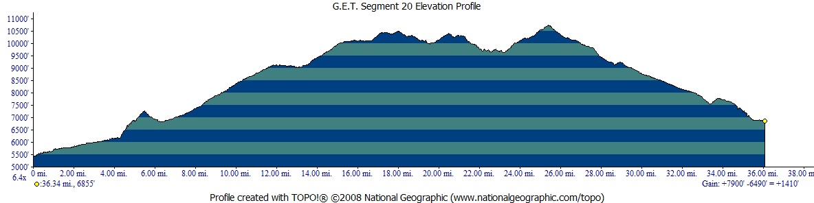
Segment 20: Mogollon Mountains 36.6
miles  Guidebook
Home Guidebook
Home
Open
this page for printing
Submit
feedback for this segment
|
Segment
Length | Segment
Status | Season |
|
|
|
36.6
mi. | unfinalized
but accessible | spring,
summer, fall | | Resources |
| OVERVIEW
MAP |  |
| ELEVATION
PROFILE |  |
G.E.T. Topo Maps 51-57
Water Chart
Image Gallery: Album 6 |
Additional maps:
Gila National Forest
(USFS)
Gila Wilderness (USFS)
Land management agencies:
Gila NF Glenwood Ranger District
(W of Mogollon Baldy)
Gila
NF Wilderness Ranger District
(E
of Mogollon Baldy)
|
| Beginning
access point | | Ending
access point | |
Mineral Creek Rd at Mineral
Creek trailhead. From
Glenwood, travel north on US 180 ~4.5 mi., then just beyond bridge over Mineral
Creek at Alma turn right onto graded dirt Mineral Creek Rd. In 3.9 mi. from Alma
the road crosses Mineral Creek (usu low water or dry here). Pass Cooney Tomb 1
mile beyond. Continue 0.7 mi farther to one of two parking areas at road's end
near trailhead signboard. The driving route from Alma to Mineral Creek trailhead
follows GET Segment 19 in its entirety.
Alternate access: NM 174 at The Catwalk NRT trailhead. From Glenwood, travel
east on paved NM 174, 4.8 miles to the trailhead at road's end. Provides direct
access to the Catwalk, which is currently being rebuilt, post-flood damage. At
this time it is not possible to continue all the way to the GET via this route,
but this should be a possibility in future seasons. (The Catwalk is open for about
half a mile, where reconstruction efforts have been completed.) | |
Trail 151 at White Creek
Administrative Site. This
segment ends within the Gila Wilderness, at a remote location accessible only
on foot or horseback. For the nearest vehicle access to the east, see the Ending
Access Point for Segment 21. | SEGMENT
OVERVIEW The
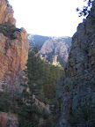
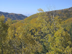
Grand Enchantment Trail here begins its extended tour of Gila Country, as this
vast and diverse region of dark forested peaks, deep sinuous canyons, sunny ponderosa
parks, and rolling desert grasslands is so well known. For the next 130 miles
our route will follow an adventurous and truly spectacular course through the
heart of this land, most of it on foot trails, a majority of which are located
in National Forest Wilderness areas. The Gila Wilderness is first accessed in
this segment, and the GET remains in its company through the end of Segment 22,
a distance of some 70 miles. Designated the world's first wilderness area on June
3, 1924, the Gila Wilderness, along with the adjacent Aldo Leopold Wilderness,
Blue Range Wilderness, and Blue Primitive Area, together form one of the larger
intact wild landscapes remaining in the contiguous United States. In
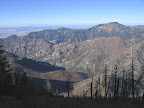
this segment the GET makes passage over the Mogollon Mountains, actually the western
rim of a giant caldera that once encompassed virtually the entire region eastward
to the Black Range. Volcanic ash deposited over eons and carved by water has formed
dramatic, steep-sided canyons such as Mineral Creek and, most notably, along the
popular Catwalk Trail, currently accessible as a day-hiking excursion from the
town of Glenwood. Beyond the canyons, our route climbs sharply to the 10,000-foot
crest of the range, topping out at Mogollon Baldy (10,770'), the highest point
on the GET. Owing
to its size and prominence, the Mogollon crest can harbor a considerable winter
snowpack and often retains it well into spring. Mountain slopes tend to be steep,
while forest trails, graded and marked for summer use, often contour across these
slopes and can be exposed and difficult to follow when snowbound. Following an
average winter's snowfall, and on a typical eastbound itinerary, spring thru-hikers
can expect to encounter snow above 9,000 or 9,500 feet, or for as many as 12 miles
of the main route in this segment. More than anywhere else along the route, the
high crest of the Mogollon Mountains in springtime can be a place for the proficient
alpine traveler only, one who possesses the ability to navigate trails hidden
beneath rotten snow and marked only with occasional tree cuts and signed junctions.
This is the reality of early season hiking atop this remote and rugged range.
(For more on snow travel, here and elsewhere along the GET, see the related Trek
Planner chapter.) For
those disinterested in such challenges, the high Mogollons are clear of snow throughout
the summer, and usually into October or November when the days here can be brisk
and glorious. Or you can instead hike the so-called High Country Bypass in this
segment, an extensive detour that circumvents the highest terrain, via Wilderness
trails and the adjacent Bursum Road, a longer route than the main GET and perhaps
harboring some spring snowpack along the road, but largely without the aforementioned
difficulties. For a further description of the High Country Bypass, see the latter
part of the Route Details info below. Snowpack
aside, trail conditions here tend to be better than what GET hikers have experienced
in parts of Arizona. Trail tread is generally well defined, most junctions are
signed, and any blowdowns cleared by dedicated Forest Service trail crews, if
not one year then probably the next. Ruggedness is still standard fare, though,
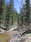
such as on the many short but unavoidable fords of Mineral Creek in the early
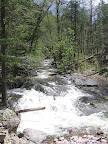
miles. Perennial water is available along this creek as well as Silver Creek,
and, toward segment's end, at White Creek and the West Fork Gila River. Several
small but fairly reliable springs are also located along or near the trail corridor
on the high crest traverse, or snow can be melted in early season, so that finding
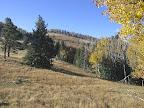
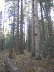
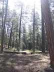
drinking water is generally not among this segment's pressing concerns. Established
trailside campsites are encountered with some frequency, although most of the
trails here are not so popular as to render these sites unattractive. Outside
of summer vacation season, the backcountry here is surprisingly little-used, considering
all that it has to offer. SPECIAL
NOTICE - WHITEWATER-BALDY FIRE IMPACTS ON SEGMENT 20: Significant
damage to trails caused by the Whitewater-Baldy
Complex Fire of 2012 and subsequent flooding has led us to realign a large
portion of this segment (whether temporarily or permanently we've yet to determine).
The new alignment, described herein (below), avoids a majority of problematic
trail damage along the prior Segment 20 main route. However the new main route
does pass unavoidably through the heart of the burn area along the Mogollon Crest,
or roughly from mile 13 through 30 of this segment, and blowdowns - while typically
cleared seasonally along these particular trails - may be present in certain sections
particularly in springtime. The High Country Bypass alternate route, now limited
to the east side of Silver Creek Divide, features its share of unavoidable fire
and flood damage, occasionally severe for shorter stretches at a time, however
hikers who have used the Bypass indicate making safe passage, albeit at a slower
than average pace. All route changes, both main and alternate, as well as trail
conditions, are also described on the current version of the GET
Topo Map Set. For additional travel options as well as the big picture view,
consult the USFS
Gila Wilderness topographic map, which shows all trails in this region at
a detailed scale and is very navigation-friendly. We continue to closely monitor
updates from the Forest Service and elsewhere on trail conditions as we decide
whether to make additional changes to the suggested route layout. Special
note to those visiting the Catwalk Trail from Glenwood: Until further notice the
Catwalk Trail is inaccessible as a thru-route due to flood damage, including to
the trail's suspended metal walkway and stairs. This trail is currently being
rebuilt (again) and is accessible (as of spring 2017) for approximately one half
mile in from the trailhead, beyond which a USFS trail closure order is in effect.
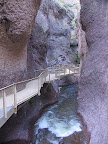
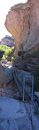
Side Hike
along the Catwalk Trail During
the region's late 19th century mining heyday, a water pipeline was built along
the narrow canyon of lower Whitewater Creek to supply the ertswhile Graham Mill
just downstream. Considered an engineering feat at the time, the suspended pipeline
nonetheless needed constant maintenance, which required workers to shimmy precariously
along its narrow length above the rockbound creek, hence the "Catwalk"
nickname. In the 1930's the CCC developed the Catwalk into a recreation trail
by installing a suspended walkway that followed the course of the pipeline. In
2005 the Forest Service completed its most recent renovation of the Catwalk Trail,
modernizing the walkway and making a portion of the trail barrier-free, but the
uniqueness of the experience, along with its history, have been preserved. 
ROUTE
DETAILS MP
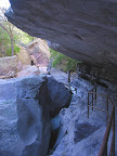
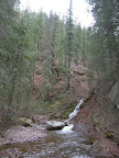
0.0 From the trailhead kiosk for Mineral Creek Trail 201 (waypoint 20010,
elev. 5420'), head east on Trail 201. The trail follows close by Mineral
Creek, then within a half mile enters a colorful, steep-walled box
canyon of ash-flow tuff, the primitive cairned trail winding past boulders and
alongside small cascades. MP
1.4 The forested trail enters Cooney Camp, historic mining area (late 1800's
era silver and gold mine), with numerous artifacts and stone ruins on display
at creekside. Trail continues to ford Mineral Creek
at intervals, often rock-hoppable or ankle-deep. Beyond mile 2 the trail is increasingly
eroded at the creek due to sporadic flooding, requiring you to clamber down and
up during crossings. MP
3.5 Signed junction with Red Canyon Trail 198 on the left (north) bank of
the creek, with good camping prospects on the bench here. Stay on Mineral Creek
Trail, which was essentially cross-country drainage walking at last check. MP
4.3 Junction with Log Canyon Trail 808 (waypoint 20040). LOOK CAREFULLY for
this junction along the right south bank of the Mineral
Creek, as it may be obscured by flood debris. A cairn may be visible
up the hill a short ways and there's an obvious side drainage coming in just before
the junction. Follow Log Canyon Trail steeply uphill along the drainage, then
as it contours and climbs toward a saddle. MP
5.5 Saddle at head of Log Canyon. Cairns lead across open terrain, then trail
descends obviously south. MP
6.4 Signed Log Canyon trailhead along the Bursum Road, with likely perennial
water in adjacent Silver Creek. Mogollon ghost
town is about a mile west (see town guide). The GET instead turns east along the
Bursum Road, a graded dirt road which was severely damaged by flooding in 2013
but has since been rebuilt and is seasonally open to vehicles again. MP
7.5 Junction with Deloche Trail 179, which heads south into the Whitewater
Creek drainage. The GET remains routed on the Bursum Rd for now, as unrepaired
trail and flood damage begin just south of this junction, although plans may be
afoot to reconstruct at least a portion of the trail network around Whitewater
Creek in coming seasons. MP
8.6 Last access to Silver Creek until
10.6, as Bursum Rd switchbacks out of the canyon. MP
10.6 Junction with Redstone Trail 206, with access to Silver
Creek (final opportunity). This trail is also damaged and probably
unusable. The GET remains on the Bursum Rd, passing over Silver Creek Divide (9100')
at 12.0. You may begin to find snow along the road in springtime, and the
route gradually enters the Whitewater-Baldy Fire burn area. MP
13.7 Signed junction with Crest Trail 182 (waypoint 20075, elev. 9132') at
Sandy Point. A vault toilet is located nearby. The main route of the GET joins
the Crest Trail, passing through frequently burned terrain all the way to mile
30, although the trail itself has been reported in generally good condition in
recent years. Aspen regrowth may be coming along nicely now in places, views are
less restricted than before, and there are still safe places to camp in patches
of living forest -- so it's not all bad news. Consider taking the main route except
in a high snow year, when the High Country Bypass, with its noteworthy
flood damage in a few places, is nonethless preferable for its lower elevations
and overall reduced exposure to snowpack. (The High Country Bypass continues east
from Sandy Point along the Bursum Road. See details in the related section of
this guidebook chapter.) MP
15.2 Junction, just inside Gila Wilderness boundary, with short side trail
heading east to Bead Spring, which has been
reported in good condition despite the burn. An area of unburned forest is located
less than half a mile before the junction -- a possible hazard tree-free camping
opportunity. MP
16.3 The Crest Trail enters another area of unburned forest, with trailside
camping possible. MP
18.5 Signed junction
at Hummingbird Saddle. Likely-reliable Hummingbird Spring
is located a couple tenths of a mile downhill to the west. Unburned forest here
and for the next mile south along the Crest Trail. Best camping is here in an
open area around 18.5. Long-lasting snow may be present in springtime as the trail
contours around the east side of Whitewater Baldy. MP
19.4 Signed junction with Iron Creek Trail 172. This trail is not recommended
for use as a connector to the High Country Bypass, as trail conditions deteriorate
heading east. Remain on the Crest Trail southward. MP
21.1 Junction of Crest Trail 182 and Holt Apache Trail 181 at a prominent
saddle. Eastbound hikers, take the left fork, remaining on Crest Trail. Living
forest is just ahead, for a third of a mile or so, with flat camping opportunities.
MP 22.0
Be careful not to walk right by Hobo Spring,
a small pool and trickle just below the trail (waypoint 20130). Nice and cold,
but water quality may not be the best; nonetheless this is the first on-trail
water source in almost 4 miles, and possibly the last for another six. MP
23.1 Little Hobo Spring (waypoint 20140)
is immediately trailside on eastbounder's left (not as reliable as Hobo Spring).
Remain on Crest Trail 182 through a junction at West Fork Saddle (23.4),
beyond which the trail gradually enters an older burn area that should present
fewer hazards in terms of blowdowns and any trail damage. MP
25.7 The Crest Trail contours, climbs, and then switchbacks up to the summit
of Mogollon Baldy. Welcome to the highest point directly along the GET! (elev.
10,770') Built in 1923, the historic cabin is staffed during fire season, when
no camping is allowed at the summit. The rest of the year the cabin is locked,
but its sheltered porch would serve as a refuge in a storm. The nearby lookout
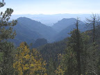
tower is likewise off-limits, although it hardly matters, as the views from this
open peak are unencumbered. Visible to the west on a clear day is distant Mount
Graham, and to the east the San Mateo Mountains (still 150 trail miles away),
beyond the long spine of the Black Range. Indeed, much of southwest New Mexico
and southeast Arizona is on display here. Leaving the summit, Crest Trail #182
becomes Mogollon Baldy Trail #152. It heads east along the gentle crest of the
forested ridge, then begins a gradual, switchbacking descent down the meadowy
southeastern slope. When snowbound, the trail would be especially difficult to
follow here, recommending a careful cross-country descent of the open, though
not exceptionally exposed slope (toward waypoint 20190). MP
27.5 Trail junction at south end of open Snow Park. (Westbounders in autumn
may find the meadow lavish with the summer's withered ferns, when the trail can
be a little difficult to follow. It heads back into the woods at waypoint 20195.)
Signed side trail on eastbounder's left, leading to fairly reliable Snow
Park Spring, 300 vertical feet downhill, in about a quarter mile. Camping
is possible near the junction, although the area is often windswept. Beyond, pass
junctions with Trail 221 and 169, remaining on Mogollon Baldy Trail 152. MP
28.4 The trail, now back within the Whitewater-Baldy Fire burn zone, passes
"Dark Spring" (waypoint 20209),
a slow-moving puddle of moisture at trailside which only became evident after
the fire, likely due to the removal of organic matter. MP
29.0 The trail descends to cross a saddle (waypoint 20210). This portion of
the trail, since re-entering the burn, had not received the same level of upkeep
as the Crest Trail, for example, and was a little hard to follow / was somewhat
rough going at times (2014). MP
29.8 The Whitewater-Baldy Fire's major effects along the trail corridor end
around here. Continuing east, Mogollon-Baldy Trail 152 enters an open ponderosa
pine forest where crown-fire conditions did not occur. The ridge gradually broadens
and the gradient slackens, making for a leisurely stroll, likely out of the snow
zone for springtime eastbounders. Final good views of the Mogollon crest appear
off to the south near 30.5, beyond which the trail continues almost due
east on a remarkably easy and steady grade, in stark contrast to the sharp western
slope of the range - the rim of the ancient caldera. MP
33.5 Keep left at a signed junction with Trail 302 (waypoint 20220), staying
on Trail 152, which switchbacks down into the little canyon of perennial White
Creek, crossing it easily at 29.5. Meadowy camp spots are off-trail,
a short ways down the drainage. The rocky trail traverses up and out of the canyon,
then turns northeast along Cub Mesa among a partially burned ponderosa forest. MP
34.6 Signed junction with West Fork Trail #151 (waypoint 20330, elev. 7650').
This spot marks the eastern terminus of the High Country Bypass, which
heads west (left) on Trail 151. (Westbounders interested in avoiding the Mogollon
crest would continue straight on Trail 151.) Turning
right (east) onto Trail 151, our route descends gradually off the mesa, crossing
and then traversing downhill along the south side of a steep drainage, where you
may find some trailside seeps. MP
36.0 Leaving the burn zone, the trail levels out again in the wide, flat-bottomed
canyon of the West Fork Gila River, turning right (southeast) at a junction with
Trail 815. (Westbounders note that this junction may be signed only for Trail
815, which remains in the canyon bottom, while Trail 151 forks left (west) and
soon climbs away.) At length Trail 151 fords the willow-lined West
Fork Gila River, which is typically 5 yards wide here, shin deep and
fairly gentle, and is the only required ford for those following the West Fork
Highwater Bypass in Segment 21 (described in that guidebook chapter). This bypass
actually begins here at the end of Segment 20, just beyond the ford, at 36.5,
where signed Trail 30 climbs out of the drainage, heading to Lilley Park. MP
36.6 Fording the Gila once more, then immediately crossing now-familiar White
Creek, just above the confluence, West Fork Trail #151 arrives at serene
White Creek Flat, with ample grassy camping opportunities. The segment ends here
by the Forest Service's White Creek Administrative Site, a rustic log cabin (locked)
that is only very sporadically staffed. (waypoint 20360, elev. 6856').
| ELEVATION
PROFILE | 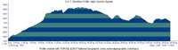 |
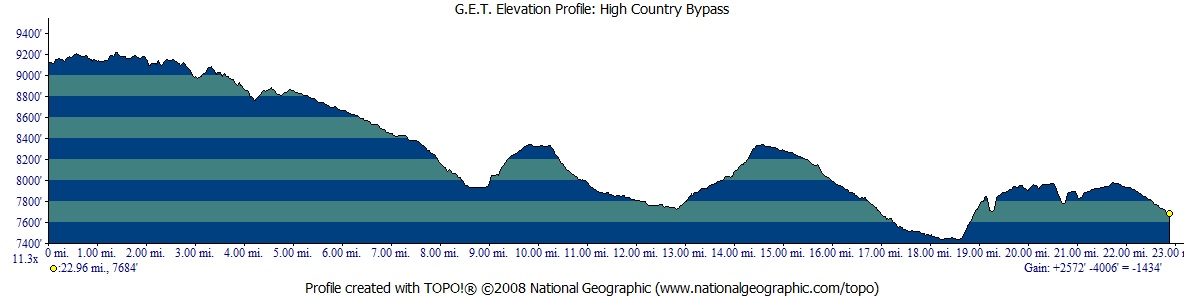
High Country
Bypass The
23-mile High Country Bypass avoids the 10,000'+ crest of the Mogollon Mountains,
in favor of an overall lower route that is less likely to harbor - though not
certain to avoid - spring season snowpack. Most snowpack is confined to the first
few miles of this alternate route located along the Bursum Road. The gently-graded
dirt road, closed to vehicles in early season, may harbor snow on its shady bends,
on and off, but without the potential for routefinding concerns of the Mogollon
Crest trails encountered on the main GET route. The bypass route then reenters
the Gila Wilderness to the east of the Mogollon Crest, where it trends south,
following a network of foot trails, here at elevations sufficiently low to promise
mostly snow-free walking. Small creeks along this stretch provide drinking water
in spring. West
to east, the High Country Bypass diverges from the main GET route at milepoint
13.7, and rejoins it again at 34.6. Making use of the 23-mile Bypass thus adds
about 2 miles to the total length of this segment as listed at the head of this
page. Although the extra distance is negligible, there is currently a 4-mile section
of this alternate route with considerable flood-related damage where the trail
- albeit likely snow-free - may be hard to follow or requires some scrambling
in eroded drainages, such that this route may be best suited for times when the
main route across the Mogollon Crest is genuinely "snowed in," such
as in a higher-snowpack spring. MP
0.0 Sandy Point trailhead and junction with Crest Trail 180 (waypoint 20075,
elev. 9132'). Head east on the Bursum Road. Snow may be present in springtime
for the first several miles of this alternate route, particularly where the road
crosses north-facing drainages. You might find occasional snowmelt
pools, or could plan to melt any snow over a stove or fire. MP
4.9 Pass the trailhead for South Fork Mineral Creek Trail #79, with decent
camping prospects across the road, among the forest. MP
5.3 Junction with FR 153 on the left (north). The ponderosa pine forest here
was burned in the Bear Fire of 2006. Continue on Bursum Road. MP
8.6 Leave the Bursum Road / NM 159 (waypoint 20270) and join the road heading
south into sprawling Willow Creek Campground (closed in early season, but accessible).
Keep to the main road, along the west side of reliable Willow
Creek, then ford the shallow creek to find the signed trailhead
for McKenzie Trail #151. MP
8.9 McKenzie Trail #151 trailhead (waypoint 20280). (Note
an outhouse nearby, perhaps the second one since entering the campground.) Trail
151 - which will later become West Fork Trail by the same route number (see Segment
21) - heads up along smaller Turkey Creek,
then traverses into a neighboring dry gully. Here it enters the Gila Wilderness,
climbing south onto Iron Creek Mesa, a sunny ponderosa park-type environment that
typifies the rolling uplands east of the Mogollon Crest. MP
10.3 Whitewater Baldy Trail #172 heads off at right (west), just before our
Trail 151 passes shallow, murky (sometimes dry) Iron
Creek Lake. A short ways beyond the lake, as the trail starts
down off the mesa, reach a junction with Iron Creek Mesa Trail #171 (waypoint
20290). Remain on Trail 151, which heads south into a prominent gully. At the
confluence with perennial Iron Creek
it turns east, down-canyon. The Iron Creek drainage and beyond, particularly to
MP 17.4, was impacted by the Whitewater Baldy Fire and subsequent flooding. As
of 2017, trail tread was mostly good, although with a decent number of downed
trees across the trail. MP
12.8 Remain on Trail 151 where it fords Iron Creek (waypoint 20300), then
turns south up Cooper Canyon, passing a turnoff
on the left (east) for Trail 141. Please note that due to severe flood damage,
as of 2017, reportedly 90 percent of the trail is gone from 12.8 to Turkeyfeather
Pass at 14.6. Scrambling roughly in or near the drainage will therefore be
necessary. Fire and flood damage are of more limited scope approaching the pass
itself, where trail tread momentarily returns. MP
14.6 Reach Turkeyfeather Pass, with Trail 102 at right (south), then Trails
175 and 164 on the left (east) in quick succession. Here our Trail 151 enters
the canyon of Turkeyfeather Creek
at its head. The likelihood of the creek flowing increases as you continue down
the canyon, frequently crossing back and forth in the narrow, v-shaped drainage.
As of 2017, the trail from the pass is initially vague but followable, then becomes
better except for downed trees. However, the last mile or so approaching the
West Fork of the Gila River at 17.4 is quite narrow with no tread, and it may
be very slippery to walk in the drainage. Some sketchy spots may exist for those
not acclimated to rough scrambling / descending in canyon drainages. MP
17.4 Turkeyfeather Creek pours into the West
Fork Gila River, normally a modest flow this close to its headwaters,
and which the trail initially fords to gain its west bank. MP
18.4 Trail 151 comes to a junction with Trail 815 (waypoint 20320), a primitive
route which remains with the West Fork and involves fording. As hikers following
the main route in Segment 21 will soon have plenty of experience with fording
the West Fork, the recommended route here instead continues with Trail 151 as
it heads toward higher ground. The trail winds briefly into the little drainage
of Cub Creek, then switchbacks up
onto pleasant Cub Mesa, offering dry camping potential. MP
20.9 Trail 151 dips to cross Packsaddle Canyon. The trail then bends east
in partially burned, open ponderosa forest to a signed junction with Trail 152
and a rejoining of the main GET route at milepoint 23.0 (waypoint
20330, elev. 7650'). (This is milepoint 34.6 of the main route. Remain on Trail
151 eastbound.) 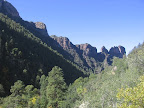

|