G.E.T.
Guidebook
Segment 26: Dolan Peak 19.3
miles  Guidebook
Home Guidebook
Home
Open
this page for printing
Submit
feedback for this segment
|
Segment
Length | Segment
Status | Season |
|
|
|
19.3
mi. | finalized
& accessible | spring,
summer, fall | | Resources |
| OVERVIEW
MAP | 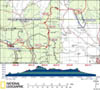 |
| ELEVATION
PROFILE | 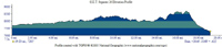 |
G.E.T. Topo Maps 67-69
Town Guide: Winston
Water Chart
Image Gallery: Album 7 |
Additional maps:
Gila National Forest (USFS)
Land management
agencies:
Gila
NF Black Range Ranger District
|
| Beginning
access point | | Ending
access point | |
NM 59 at CDT (Trail 74).
5 miles north of
Truth or Consequences NM take exit 83 off Interstate 25 onto paved NM 181 North,
then turn left onto paved NM 52 (west). In ~31 mi. from I-25, reach community
of Winston (last gas station). Continue
~10 more mi. and turn left onto paved NM 59. Follow ~13 miles to signed crossing
of Continental Divide. Continue 0.5 mi. to CDT trailhead and parking.
| | FR
913 at Trail 60. 5
miles north of Truth or Consequences NM take exit 83 off Interstate 25 onto paved
NM 181 North, then turn left onto paved NM 52 (west). In ~31 mi. from I-25, reach
community of Winston (last gas station.
In ~10 more mi. pass junction with NM 59, remaining on NM 52 which becomes a graded
dirt road. In ~4 mi. turn left (west) onto lesser dirt road signed for National
Forest access. High-clearance 4WD recommended beyond this point. In ~2 more miles
turn right at a junction, following road out of Silver Creek wash up to mesa,
reaching Gila NF boundary in ~3 miles. Trailhead access is approx. 5 road miles
beyond this point in Duck Canyon, south of waypoint 27010 as indicated on topo
mapset. To navigate confusing road network, GPS (esp. with satellite imagery)
recommended. Contact USFS for current road conditions and status of private inholdings
en route. (Please note: No vehicle access to trailhead from Dusty area due to
locked gates.) | PLEASE
NOTE: THIS CHAPTER REMAINS UNFINISHED. SEGMENT OVERVIEW AND ROUTE DETAILS INFO
BELOW ARE IN DRAFT FORM AND HIGHLIGHT ONLY THE ESSENTIALS NEEDED FOR NAVIGATING
THIS SEGMENT IN CONJUNCTION WITH THE TOPO MAP SET. SEGMENT
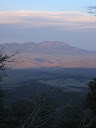
OVERVIEW The
GET's 40+ mile tour of the Continental Divide Trail across the Black Range reaches
its conclusion in this segment, as the two routes part ways, bound for different
destinations. The CDT nearly reaches the northern limit of the Black Range here
and, running out of both mountain and Forest Service land, is soon forced westward
where it remains with an increasingly arid Divide - BLM country - skirting the
southern bounds of the vast Plains of San Agustin. Instead, the GET ventures easterly
out of the Black Range, journeying by and by toward more well-watered country
along Alamosa Creek and the San Mateo Mountains ahead along our route. That initial
descent from the Continental Divide serves to conclude this segment; it also represents
one of the more sustained descents in a number of miles (or rather, sustained
climbs, more to the point for westbound hikers in search of the Divide). Otherwise,
this segment is a mostly mellow walk, on par with the latter portion of Segment
24. Eastbound
hikers, trending north of late, will find more good tread along the CDT in this
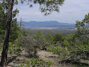
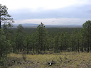
segment contouring at or near the physical Divide, more peek-a-boo far-flung views
through the ponderosa pines, more remote walking and solitude, and yes... more
potential drinking water concerns as well. Adobe Spring - 11 miles in from the
trailhead, and upwards of a half mile off-route - is a fine source in a bedrock
drainage but is not reliable in drier times. It's certainly a better option than
Dry Time Tank farther along, which wasn't named for its resiliency so much as
its Achilles' heel: it sometimes goes dry*. And as a former stock impoundment
of sorts, now watering more elk than cows, it's typically quite silty whenever
it does happen to be wet. (*The author, hiking in the fall, has actually never
seen either of these two sources dry, but a trio of reports from spring '09 indicated
no water at either location by late April, so perhaps summer rains are more beneficial
than melting snowpack in this area.) The good news for thirsty hikers is that
a solar well feeding a large metal tank is located just beyond segment's end.
(This is in addition to several likely developed sources ahead in Segment 27.)
Westbounders: check the weather. If it's been dry for some time, consider camping
within reach of one of Segment 27's sources, then tanking up; it's a long uphill
push to the Divide and the walking may well prove droughty up there.
ROUTE
DETAILS From
the large CDT trailhead half a mile west of the physical Divide along NM 59, walk
north across the highway to find a continuation of CDT singletrack, which heads
leisurely across a ponderosa-pine-dotted meadow. The trail then bends east, winding
gently up along a shady north-facing slope, then leveling out as it crests the
broad Divide. Singletrack ends at a junction with a 2-track road at 0.7
(waypoint 26020), onto which the CDT route turns left (northeast). (Westbounders,
following the 2-track, look carefully for a pair of small cairns flanking the
trail where singletrack discretely diverges right off of the road. If you reach
a car camping spot at right along the 2-track, you missed the turnoff.) At
the Divide, a dirt road forms a loop on the north side of the highway. The
tree-blazed CDT continues northeast via 2-track initially. Within a half mile
watch for where trail tread (more like a wide swath) splits from the 2-track at
left, possibly not well marked or marked with flagging tape. The trail passes
through an open area, burned of late. Before long the trail becomes better defined
as it exits the burn. After
dipping to cross a little flat at 1.7, where a 2-track road may be visible
heading south, the trail - itself somewhat wide at times - resumes a gradual northeast
ascent along the broad forested ridge. The trail meets a fence corner at 2.7,
passing through a gate here. Then at 3.3 it meets another gate in a north-south
oriented fence, and crosses it where this fence meets a corner, passing through
both fences via gates. Beyond
yet another gate (waypoint 26060) the trail descends along the ridge, then runs
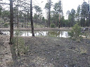
near a little drainage for a short distance, leveling out here. Surprisingly this
drainage sometimes holds pools of water for
several weeks following a good rain. By all means plan to scout around (in the
vicinity of waypoint 26065), but don't depend on this source in advance; should
you find water you'll be that much better off in the event that Adobe Spring (MP
11.1) is dry. (Westbounders approach the drainage after passing through a metal
gate near 4.0.) Concluding
the drainage scouting and back on trail, now pass through a green metal gate at
4.0 (waypoint 26068). Another one is at 5.2, and a wire gate at
6.6. Indeed, the north-south fenceline continues to be a frequent companion
for the remaining at-Divide tour. The trail, which occasionally joins and leaves
various 2-track roads as they come in and head away from the fence corridor, at
intervals crosses this fence back and forth via gates, and never strays far from
it. The CDT often runs along the Divide proper, ill-defined though the physical
Divide here sometimes is. Other times, as at Dolan Peak and its northern cousin,
the trail skirts an otherwise unnecessary climb via contouring tread. Following
the trail - marked with i-blazes and metal markers on trees - through its various
changes is not difficult. As
the trail descends northeast from point 8215 plan to drop into the next drainage,
which the trail skirts the head of (11.1; waypoint 26100 or thereabouts),
and detour west cross-country in search of Adobe Spring.
The spring is located near the intersection with the next main drainage to the
north; if no pools are noted in the bedrocky drainage just by the junction, head
down-canyon a bit farther in search of any wet spots or flow (but probably none
beyond a 10-foot pour-off you'll eventually encounter). To return to the CDT/GET,
you can cut off a half mile of the main route, shortening the detour, by walking
up the other drainage, then leaving it within a few tenths of a mile, x-c north
to a paralleling 4WD road. Follow the road east to find the trail at our familiar
fenceline atop the Divide. (Westbounders, to visit Adobe Spring keep right
(west) on the 4WD road where the CDT continues south as singletrack by the fenceline
at 11.7. As the drainage just south draws nearer to the road, head x-c into it
and continue west to the junction with the next drainage south. Look for pools
here or below, then return to the Divide via the other drainage.) The
trail is mostly on 4WD road north to 12.7. Here pass through
a swinging metal gate by a powerline swath to find the continuation of trail tread,
which parallels the 4WD on the east side of the fence, sometimes closely. Tread
is occasionally vague or non-existent to 14.7, but i-blazes, metal markers, and
cairns are never far away for guidance. The trail runs well away from the 4WD
when ascending the flanks of point 8365, where a careful eye is sometimes needed
to spot trail markers. At length it descends to meet another 4WD/2-track (mapped
"Trail 59"), with a CDT sign here (14.7). Continue
across the road to find resumption of tread. Dry Time
Tank (waypoint 26130) is just north along the east side of the 2-track,
a smallish earthen impoundment with shallow murky water in the best of times (no
cows noted). Good, bad, or ugly, this is the only potential source in this area,
as the "former location" of Dry Time Tank impoundment as mapped must
have been washed out by flooding a number of years ago. (The drainage heading
south, via Trail 59, has also been verified dry.) Camping is possible in the vicinity. The
vague-ish trail continues east in wide open forest, but occasional cairns guide
the way. Ascending a bit, the trail bends briefly south to begin a short section
of switchbacks up a steeper slope, with better tread. The switchbacks terminate
at another wire fenceline, where the CDT / GET turns left (east) along its swath,
ascending the fall line gradient to the top of the rise. Here (15.4,
waypoint 26140) a prominent cairn marks the point of eastbound hikers' departure
from the CDT; the CDT turns left (north) while we continue east with the fenceline
corridor, which is known here as Trail 60, though is unsigned throughout. (Westbounders,
from the cairned junction with the CDT at 15.4, continue west with the fenceline
swath downhill and look for trail tread soon departing at right, where the CDT
/ GET begins a switchbacking descent toward Dry Time Tank environs.) Trail
60 is often virtually treadless, but easy going enough, as it follows the north
side of the fenceline eastbound to a saddle then over another rise. Stay north
of the fence, ignoring any openings in it, until you reach the next full-fledged
saddle, at around 16.6. Here the fenceline is offset to the left with an
open gate at the jog; keep straight, such that the fenceline is now on your left
as you follow its south side. (Westbounders, continue straight at the fenceline
jog at 16.6, such that the fenceline is now on your left instead of your right.
Keep to the same side all the way to the CDT junction.) Climb
to the south shoulder of 8800' Wahoo Peak at around 16.9, ignoring
an opening in the fence. Still the fence remains on your left as the trail now
descends eastbound in earnest with only brief reprieves in the 15-20% gradient.
(Westbounders pause to catch their breath, and to take in the expansive views
through the open forest, back toward the Apache Kid and Withington wilderness
areas.) This portion of Trail 60 was rebuilt in 2011, but only to make it
more evident here and not, unfortunately, any less steep. The vegetation is predominantly
pinyon-juniper by the time the fenceline-hugging trail reaches a flattish area
along the ridge near 18.6 (waypoint 26160). Do not continue
with the fenceline beyond here. Instead, follow the trail as it bears
right (south-southeast) away from it, toward a prominent knoll along the ridge.
Trail 60 now
countours along the north side of the prominent knoll on another section of 2011-constructed
tread, well-designed in this case and all-but-non-existent prior to that time.
Some interesting rock outcrops at left, where the trail heads over a little outlying
ridge, frame views of Black Range foothills to the north, inviting pause. The
trail rounds the knoll clockwise to another saddle, this one between our knoll
and a lesser one immediately east. Segment 26 terminates here at the saddle (19.3,
waypoint 27010, elev. 7340'). Segment 27 starts north along the adjacent fenceline
swath, which is not a continuation of Trail 60. (Trail 60 instead continues
south, with occasional cairns, following near the fenceline and becoming more
of an old road or swath before ending by an ad hoc parking area along a feeder
road of FR 913. A solar well and tank, and
adjacent stock pond, are located nearby this "trailhead" - refer to
the topo mapset, water chart, and the Segment 27 guidebook chapter for more info.) |