G.E.T.
Guidebook
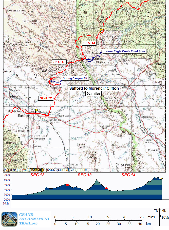
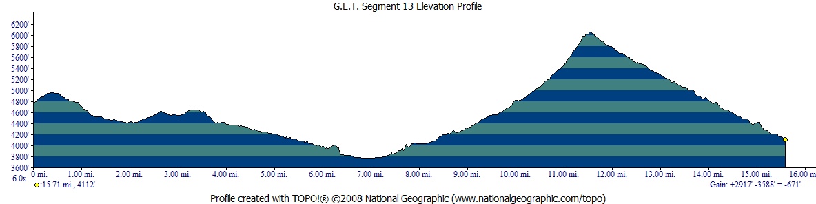
Segment 13: Old Safford-Morenci Trail 15.8
miles  Guidebook
Home Guidebook
Home
Open
this page for printing
Submit
feedback for this segment
|
Segment
Length | Segment
Status | Season |
|
|
|
15.8
mi. | finalized
& accessible | fall,
winter, spring | | Resources |
| OVERVIEW
MAP | 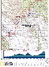 |
| ELEVATION
PROFILE | 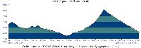 |
G.E.T. Topo Maps 38-39
Water Chart
Image Gallery: Album 4
| Additional
maps:
Safford 1:100K Topographic (BLM)
Clifton 1:100K Topographic (BLM)
Land management agency:
BLM Safford Field Office
|
| Beginning
access point | | Ending
access point | |
Old Safford-Morenci Trail
west trailhead. From
US 70 (Thatcher Blvd) at 8th Ave in Safford, head north on 8th Ave. In 1.5 mi.
bear right at the fork onto Airport Rd. and follow it 4 miles to Aviation Way.
Turn left here, then immediately left again onto (unsigned) Solomon Pass Rd (which
becomes graded dirt) and continue 8 miles to the Solomon Pass-Salt Trap Road junction.
Bear left onto Salt Trap Road and follow it 1.8 miles. Turn left (waypoint 12135;
if you reached Salt Trap tank and corral you missed this turn) and continue ~4
miles to the signed trailhead, a dirt turnout with ample parking. A 4WD high-clearance
vehicle may be needed for sections of the last 6 miles. | |
Old Safford-Morenci Trail
east trailhead. From
Clifton take US 191 (Coronado Bvd) north to the town of Morenci. Continue another
~5 miles and turn left onto signed, graded dirt Lower Eagle Creek Rd a short ways
before ridge-top overlooks of the mine. The road descends to the flood plain of
Eagle Creek in another 5.5 miles, where it turns left past a pumping facility,
then right to cross the creek. A high-clearance 4WD vehicle is often advisable
here and beyond. Now on unsigned Black River Rd (the same road changes names),
continue ~1.6 miles, along the way ignoring a side road at right, to the signed
Old Safford-Morenci Trail east trailhead. Parking for several vehicles is available
along the roadside opposite and just beyond the trailhead sign. |
SEGMENT
OVERVIEW This
segment follows the historic Old Safford-Morenci Trail in its entirety. The BLM's
Safford Field Office website offers the following description of the trail: "Pioneer
ranchers and farmers in the Gila Valley built this trail about 1874 to haul their
products to the booming mines of the Clifton-Morenci area. After the advent of
the automobile in the early 1900s, new roads were constructed along other routes.
One was the Safford-Clifton Road (now called the Black Hills Back Country Byway).
Decreasing use of the Safford-Morenci Trail resulted in little maintenance, and
it became more difficult to follow. Today, the Safford-Morenci Trail is managed
by the BLM as a recreation trail for non-motorized uses. Although the trail was
originally used as a pack trail for supplying mining camps in and around Morenci
it is now impassable in places for horseback riders. "Hikers
can enjoy a variety of desert and riparian environments along the trail. Bonita
Creek, part of the Gila Box Riparian National Conservation Area, is crossed about
midway and makes a good primitive camping spot. Javelina, black bear, mule deer,
bighorn sheep, and mountain lions inhabit this area. Numerous birds, including
raptors such as golden eagles and peregrine falcons, may also be seen. Riparian
areas are especially good for colorful neotropical migratory birds. Hikers can
encounter prehistoric cliff dwellings, remnants of early homesteads, majestic
rock outcrops, and sweeping views of the Gila Box Riparian National Conservation
Area, the Gila Mountains, and the high points beyond." Thanks
to the ongoing efforts of the BLM in Safford, the Old Safford-Morenci Trail is
now well on its way to becoming one of southeast Arizona's premier longer-distance
desert trails. Several miles of reconstructed and expanded trail make for easier,
more enjoyable passage than was once the case, and more work is planned for coming
seasons. The Old Safford-Morenci Trail follows a combination of foot trail, 4WD
tracks, and cross-county drainages, and features occasional brown and (older)
green metal signs marked "TRAIL," as well as carsonite posts and cairns. With
the exception of perennial Bonita Creek, only a spring in South Smith Canyon near
the end of this segment should be considered generally reliable in drier times.
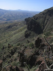
Where the route follows drainages, expect an exceedingly rocky go of it at times,
but also a wonderful sense of solitude and even the occasional section of scenic
slot canyon to explore. Please
note that the "official" total mileage listed for this segment, while generally
accurate, may feel a bit underestimated due to the rough terrain in places. Budget
your time and energy accordingly.
ROUTE
DETAILS At
the Old Safford-Morenci Trail west trailhead (waypoint 12200, el. 4700') sign
the user register, then proceed north on trail tread. The well-defined trail soon
turns east and climbs a bit to a low saddle, then descends north into a canyon
among pinyon pines and junipers. At 0.9 of a mile, pass through a fence
opening. The trail soon crosses the drainage several times as it continues downhill,
eventually settling on its west side. Emerge
from the narrow canyon to cross a rocky wash at 1.3. Cairns may assist
in following the trail, such as where it turns sharply right less than 0.1 mi.
beyond the wash. Cross the drainage again at 1.7 (waypoint 13030). The
route now follows a wide track, soon passing a potential dry camp at right among
the pinyons. The track crosses the drainage three more times, then climbs out
on the left with rocks lining the sides of the meandering treadway. Passing over
the berm of a dry stock pond (2.2, waypoint 13040) the trail contours into
a little canyon, following along its west side, before joining the drainage itself
just above an old mortar dam. Soon reach a 4WD road and wooden Safford-Morenci
Trail sign at 2.4 (waypoint 13050). Turn left (northeast) onto the road.
(Westbounders, look for the wooden sign at right as the road reaches the drainage.) The
4WD road undulates northward in pleasant, open country, passing a couple of tracks
that head off at right. The second track (waypoint 13060) leads over to the corral
and stock pond partially visible eastward, an unreliable source. Following
a steep descent, reach the wide wash of Johnny Creek and a Safford-Morenci Trail
sign at 3.8. A de facto vehicle camping area is ahead a short distance
along the road, with live-oak shade. Our route turns right (east), rejoining foot
trail, first in the wash then along its banks. 2010-2012 constructed trail now
does a commendable job of keeping to the banks while avoiding much prolonged travel
in the rocky drainage itself. But watch carefully for where the trail frequently
crosses over the creek as well as where it occasionally climbs away for a short
spell, for example to avoid a low cement dam across the drainage at 4.8,
apparently an artifact from the trade route's former heyday (the trail previously
required an awkward decent of this dam, impassable for stock animals).. As
of this writing constructed trail continued to 5.2 (waypoint 13100). Eastbound,
the Safford-Morenci Trail then proceeds entirely in Johnny Creek's wash for about
a mile. The wash remains very rocky, so expect a sub-2mph hiking pace through
here. Ahead, the canyon
features several minor slots that occasionally hold pools
of water. Beyond the slots, watch for a trail sign and cairn marking
where foot trail leaves the drainage at left (milepoint 6.1, waypoint 13110).
The trail climbs around an impassable pour-off in the drainage below, while offering
an interesting vantage of Bonita Creek's riparian corridor and the colorful ridge
of Turtle Mountain beyond. Descend sharply back to the canyon bottom at 6.4
(waypoint 13120). Here a 2012-constructed section of trail avoids the rocky
wash in favor of the more subdued north side of the canyon bottom, following the
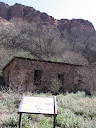
flood plain east. It passes an old 3-sided stone structure, where it enters a
mesquite bosque and turns more northerly, then comes to a signed junction at 6.9
along the west bank of Bonita Creek (waypoint
13130, elev. 3780'). Here a side trail continues north to the historic Old Lady
Gay Cabin, a pioneer-era homestead now restored by the BLM and located less than
a half mile up-canyon (you'll pass an old wooden corral chute, then cross Bonita
Creek to the east side to find the cabin 100-200 yards farther upstream. The final
jaunt to the cabin is more of a cross-country walk through the riparian forest). Continuing
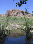
on the Safford-Morenci Trail, ford the normally gentle, ankle-to-shin-deep flow
of Bonita Creek. The creek setting is very attractive in its corridor of cottonwoods,
willows, and sycamores. Beaver activity has been increasing in this area, with
dam construction frequently altering the creek's flow and making crossing (and
perhaps refinding the trail on the opposite side) a little more challenging. As
of this writing, a carsonite post marked the continuation of trail beyond the
crossing (33.01285° N 109.55645° W) - this is located some yards downstream from
where you first meet the creek, heading east. The trail then joins an overgrown
roadbed, before entering a grassy, sycamore-shaded, camp-friendly flat. Continuing
south, the trail corridor defined by logs in places, you'll re-enter mesquite
bosque before returning to Bonita Creek's flood plain briefly. Here find a way
through the brush, remaining at the edge of forest, to a confluence with the drainage
of Midnight Canyon at a metal TRAIL sign (7.2, waypoint 13140). You may
note a small cliff dwelling on the canyon wall to the northeast, actually a prehistoric
granary; the cliffs are now too fragile to permit up-close inspection. At
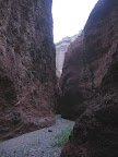
Midnight Canyon's wash, the Safford-Morenci Trail turns left (east) and follows
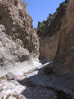
the wide wash up-canyon. The canyon eventually narrows to a slot and becomes quite
dramatic, with red-rock conglomerate walls occasionally only a few feet wide.
About half-way through the slot a series of mortared steps allows passage over
a pour-off, presumably built to assist pack animals in the trail's early days.
The steps also serve to contain pools of water
in wetter times. Beyond the slot, turn left (north) where the drainage forks (waypoint
13150) and follow the wash to a 4WD crossing, at 8.5 (waypoint 13160). The
Safford-Morenci Trail now turns left (north) onto 4WD East Bonita Rim Rd, which
crosses the drainage again at 9.1. Keep straight at the junction with signed
Christensen Rd at 9.8. Toppy's Cave, named for the reclusive cattle rustler
Toppy Johnson who once called it home, is located in the impressive volcanic cliff
face high on Turtle Mountain to the east. Stay on E. Bonita Rim Rd to 10.4
(waypoint 13180), where recently reconstructed trail heads left. The
well-graded trail ascends with occasional switchbacks to the head of Midnight
Canyon. Trail crews have done a commendable job in smoothing the way through this
surpassingly rocky landscape, although the trail tread will be difficult to keep
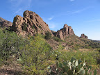
free of brush without more frequent use. Reach the broad ridge of Turtle Mountain
by an open gate at 11.7 (waypoint 13190, el. 6060'). This is Bellmeyer
Saddle, the literal and figurative high point of the Old Safford-Morenci Trail.
Be sure to walk the short distance over to the saddle's impressive westward outlook;
the panorama includes lower Midnight Canyon, upper Bonita Creek, the Gila Mountains,
and beyond, floating like a vision on the horizon, the high crest of the Pinaleño
Mountains. Nearby you may find the memorial to Albert Bellmeyer, a pile of rocks
marking the spot where he was ambushed and killed in 1892 by Apaches for grazing
cattle on Indian land. (Bellmeyer may have been killed by the legendary Apache
Kid, whose own gravesite the G.E.T. passes at Cyclone Saddle in the San Mateo
Mountains (Segment 28), a similarly remote, mountainous spot where the renegade
"Kid" was allegedly ambushed by area ranchers in retribution for his
many attacks.) From
the saddle, the Safford-Morenci Trail enters a remote corner of the San Carlos
Apache tribe for the next half mile, where you shouldn't camp. The trail proceeds
southeast into the head of South Smith Canyon, at first with views eastward toward
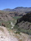
Morenci Mine and the distant Mogollon Mountains. Initially the trail follows the
south bank of the drainage, then meanders back and forth in the drainage bottom
as it widens down-canyon. Although very cobbly (as elsewhere) and somewhat slow-going,
the canyon bottom is enjoyable for its low, shady canopy of oak, pinyon pine,
and juniper. A carsonite post may indicate where the trail reenters public lands
at 12.2 (waypoint 13200). The
trail becomes a wide, rocky track soon before a side canyon joins from the left
at 13.9, (waypoint 13210). (Westbounders, take the left fork, perhaps
noting green metal TRAIL signs.) Singletrack trail resumes below the fork,
but ends back at the old road by a metal sign and cairn, just west of a metal
stock tank and trough (which sometimes has
a bit of algae- and insect-bespangled water). Another canyon merges, this time
from the right, at 14.3 (waypoint 13230). (Westbounders be sure to keep
right here; don't mistake this fork for the one ahead at 13.9.) Mature
cottonwoods and willows shade the little oasis surrounding Smith
Spring, A metal pipe runs from the spring source in the cliff face
above to the vicinity of an old wooden structure; listen for a trickle of water
from the pipe's outlet, which is somewhat hidden by brush in the drainage here.
You may also find pools and some flow where the trail crosses the drainage below.
Just beyond, at 15.0, the trail passes through a wire gate (not intact
as of 2014), where a small trough, fed by the spring, often overflows with excellent
water. This shady area would make for an ideal camp, if not for the ubiquitous
rocks; thankfully for eastbounders there's better camping available not far ahead
in Segment 14. Continue down the rough 4WD track, with views ahead to the Morenci
Mine. Pass through a gate by a trail register, less than 100 yards before reaching
the Old Safford-Morenci Trail east trailhead on Black River Road (milepoint 15.8,
waypoint 13250, el. 4100'). |