Precautions
"What
constitute the pleasures of the traveler are obstacles, fatigue or even danger.
What charm can there be in a journey when one is always sure to arrive and find
his horses ready, a downy bed, an excellent supper and all the comfort one enjoys
at home? One of the great misfortunes of modern life is the absence of the unexpected,
the lack of adventure. Everything is so well regulated, so well fitted into its
place and ticketed, that chance is no longer possible; another century of improvements,
and everybody will be able to foresee from the very day of his birth all that
will happen to him up to the day of his death."
- Monsieur Theophile
Gautier, 1840
 An
in-depth discussion of the hazards and inconveniences associated with long-distance
hiking and wilderness travel would fill several volumes, and would likely serve
only to discourage the uninitiated and amuse the experienced. The following list
intends to do neither, but merely to mention a few additional precautions you
may want to consider before embarking on an extended hike in this part of the
country. As elsewhere in this Trek Planner, the purpose here is simply to present
the realities of the experience so that you can decide whether or not to attempt
such a hike yourself.
An
in-depth discussion of the hazards and inconveniences associated with long-distance
hiking and wilderness travel would fill several volumes, and would likely serve
only to discourage the uninitiated and amuse the experienced. The following list
intends to do neither, but merely to mention a few additional precautions you
may want to consider before embarking on an extended hike in this part of the
country. As elsewhere in this Trek Planner, the purpose here is simply to present
the realities of the experience so that you can decide whether or not to attempt
such a hike yourself.
Snowpack
Can
occur in highest terrain during spring. Challenges include postholing, hard-to-follow
trails, and risk of sliding accidents.
What
to Do:
Assess
challenges and determine whether detouring is worthwhile. If confronting extensive
snowpack, bring instep crampons and occasionally an ice axe. Watch for moats near
trees and other melting hazards. Use guidebook, map, compass, and GPS to remain
on trail, unless hazards warrant otherwise. Set a slow, steady pace, and always
consider turning back if conditions worsen. See the section on Snow
Travel.
High Water
Can
occur on certain creeks and rivers during spring. Challenges include difficult
fords, slow tiring progress, chilly water, slick rocks, and continuously wet feet.
What to Do:
Assess
challenges by examining river, then decide whether detouring is necessary. If
fording, unfasten backpack hipbelt, face upstream and brace against the current
using a stout stick or hiking pole. Test the creek bottom before putting weight
onto the next foot. Move slowly but deliberately. Ignore the distraction of cold
water, which is only temporarily uncomfortable. Turn back if water deepens unexpectedly
or current increases. Wear lightweight, breathable footwear which will dry quickly,
or carry fording sandals. See the section on Creek
Fording.
Heat
& Sun
During
prime thru-hiker seasons, daytime temperatures in the 70s and 80s are common in
the low country, with occasional 90's F. Low humidity means strong sunshine and
high UV, especially in spring.
What
to Do:
Drink
frequently. Find shade in riparian zones, beside stock tanks and cliffs. Wear
lightweight, light colored, loose-fitting clothing, including long sleeve shirt
and pants when the sun is strongest. Wear a wide-brimmed hat and consider carrying
a solar-reflective umbrella if particularly sensitive. Carry a small supply of
sunscreen to augment clothing.
Thorny
Plants & Brush
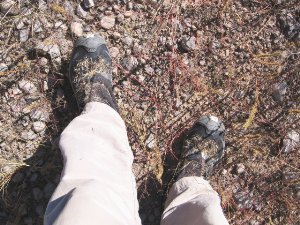 |
| Grass
seed loves mesh footwear in autumn |
Cactus
and other thorny plants are common below 6000', and trails are sometimes narrow
and brushy. Burrs, thistle, grama grass seed, and other stickers near ground level
can be a painful nuisance in places during autumn.
What
to Do:
Wear
long sleeves or a lightweight shell jacket in heavy brush, and convertible pants
with scree gaiters to keep legs scratch-free and socks free of burrs. Cover mesh
running shoe uppers with duct tape if stickers poke through, or better yet avoid
mesh footwear altogether following a heavy monsoon season. Cactus spines and segments
can be removed from skin using a comb (never your fingers). The fine hairs of
prickly pear cactus can be detached with duct tape.
Insects
 |
| Scorpion
preying nocturnally on ants & spiders |
Mosquitoes
are infrequently of concern, usually in evening near water in early spring. Flies
and gnats can be a nuisance on warm spring days, but seldom bite. Ticks are rarely
encountered, and do not generally spread diseases such as Lyme. Scorpions occur
in lower elevations throughout, can be locally abundant on mild nights from spring
through autumn in Arizona, and basic precautions should be taken to avoid encounters.
What to Do:
For
mosquitoes, carry a very small container of repellant or wear a headnet if camping
in the open. Avoid scorpions, which are active at night, by camping away from
rocky portions of drainages and not digging in sand. Use a ground sheet beneath
a tarp, or carry a lightweight tent. Inspect footwear, loose clothing, and the
undersides of gear in the morning. (Hang these items from tree limbs or bushes
during the night if concerned.) Day or night, check the undersides of rocks and
decaying wood before grabbing these objects off the ground. Read the book Medicine
For Mountaineering (Wilkerson) for an understanding of reactions and concerns
in the uncommon event of a scorpion sting. Although an unwanted guest in camp,
scorpions like other wild critters want to avoid you and will not usually sting
unless provoked. (The author has sat unclothed and unharmed among rocks later
noted to be crawling with scorpions.)
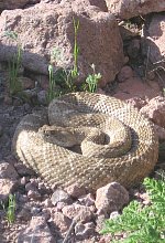
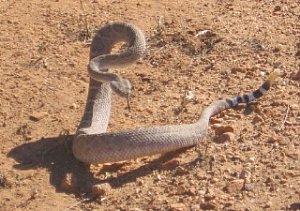
Snakes
Several
species of rattlesnake occur throughout the region, most notably the western diamondback.
All are more commonly seen by thru-hikers in spring than fall, particularly in
Arizona below 5000'. General precautions should be taken to avoid unfavorable
encounters.
 |
Western
diamondback rattlesnake wakes defensively
from sleep along the road bed |
What
to Do:
Remain
alert. Get in the habit of scanning the trail or road ahead for sunbathing or
dormant snakes which tend not to rattle unless you approach closely. Avoid nighthiking
on overgrown trail and obscure roadways. Keep your hands in sight if exploring
rocky areas. Wear long pants and gaiters. Learn to reflexively back away from
close encounters, then circumvent the snake and continue on. If a snake approaches
as you rest, it is probably hunting for small prey and will ignore you if you
remain still. (Nighttime encounters at camp are unusual.) Learn to distinguish
venomous snakes from their non-venomous lookalikes. Read the book Medicine
For Mountaineering (Wilkerson) for protocol on what to do in the uncommon
event that you are bitten.
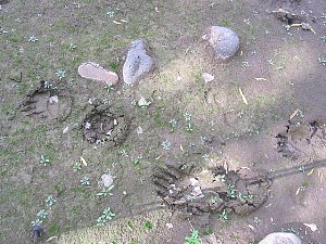 |
| Black
bear tracks at the banks of the Blue River |
Large
Critters
Black
bear are common in wooded mountains, as are mountain lions in desert canyons.
(You are likely to see a bear or two, and perhaps hear a lion at night.) These
animals are generally wild and unadapted to humans, so the risk of aggressive
encounters is quite low. At the present time, hanging food from bears at night
usually is not necessary, except perhaps at established campgrounds.
Mice
Well
known for marauding shelters and campsites on other trails, mice tend to keep
a low profile on the G.E.T. Avoid established campsites near water for best odds,
or hang food and gear from any available object to easily thwart most encounters.
Lightning
Thunderstorms
are less common in spring and fall, although westbound hikers may experience lingering
effects of monsoonal moisture in September. Lightning can sometimes be frequent
and vivid, and downpours brief but heavy.
What
to Do:
Watch
clouds in late morning or early afternoon for signs of thunderstorm development.
Plan ahead to avoid open areas or ridgelines in the path of storms. Avoid traveling
in narrow canyons, or camping in washes, whenever heavy rain may be occurring
regionally.
Flash
Floods
Usually
associated with the summer thunderstorm season, flash floods can occur anytime
a significant amount of rain falls over a short period of time. They're of greatest
concern in narrow box canyons and slots, the first of which are fairly common
along the GET.
What
to Do:
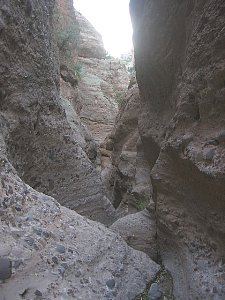 |
| Gold
Gulch near Eagle Creek |
Watch
clouds in late morning or early afternoon for signs of thunderstorm development.
Be cautious anytime heavy rain may be occuring regionally. Avoid traveling in
narrow canyons or camping in washes at these times. Small creeks will often subside
quickly after a rain storm, and you may be able to wait for safer fording conditions.
Larger creeks crest and subside more slowly; if in doubt, turn around and find
another way across.
Off-route
Travel
Several
slot canyons are located near the route, some of which are available as side-trips.
A few become semi-technical as they progress, and should not be attempted in full
without adequate experience. Above all else, do not climb down anything that you
cannot safely climb back up.
Wildfire
The
wildfire season in the Southwest normally runs from May through September, the
same months during which G.E.T. hikers may find some of the mountain fire lookout
sites staffed. A primary fire threat early in the season comes from so-called
dry lightning - produced by thunderstorms that bring little rain which would otherwise
limit or extinguish the fires they sometimes spark. Now recognizing the essential
and beneficial role that wildfire plays in the health of the forest ecology, the
US Forest Service increasingly opts to fight only those naturally-occuring fires
which threaten human life or property, or which risk becoming particularly aggressive.
Lower, less aggressive ground fires are frequently allowed to burn, merely guided
by the hand of man in order to achieve resource objectives.
While
the risk of crossing paths with an encroaching wildfire is small, it's still a
good idea to monitor the location of any smokes you may see on the near horizon.
During times of high fire danger it also doesn't hurt to check in with the US
Forest Service ranger districts along the route, in advance of entering a particular
area, to verify whether any closure orders may be in place, and if so, what detour
options may be appropriate. You can also keep apprised of any active wildfires
via the inciweb.nwcg.gov website.
Human
Encounters
Away
from towns and popular areas, you are more likely to encounter ranchers than anyone
else. Most will be friendly and curious, and some may volunteer water or other
kindnesses to those in need. Avoid trespassing, though, to insure a positive experience
for the next hiker. Elk and deer hunters are sometimes encountered in fall; wear
blaze orange as appropriate. Trail user conflicts are uncommon due to limited
traffic.
Private
Property
In
order to maintain the good will of property owners as well as the communities
along the way that trail users depend upon, it is important to be aware that private
property without an easement or public road facilitating passage is off-limits
unless specific permission has been granted. If you happen to encounter private
property and are not sure whether you have a right to pass through, your best
bet is always to find another way, even if it means turning around. Even if the
route information at your disposal - whether from this website, from a road atlas,
forest service map, etc. - depicts the route ahead as being open, property boundaries
or private landowner relationships may have changed in the meantime. Should a
landowner confront you, never use the information on this website or the maps
or information on your person as a defense. For many reasons it is usually best
to stop, listen, and then do as requested, without any objection. Your fellow
hikers will surely appreciate it.
Hitchhiking
Hitchhiking
can be a safe and practical way of accessing some of the more distant trail towns
along the way. Because the G.E.T. is conceptual and "new", however,
few are likely to recognize you as a long-distance hiker per se. Most locals will
be able to distinguish you from a drifter, however, and I have found that certain
cultures in the region are very keen to offer rides to anyone who looks in need.
What to Do:
For
best results, stand and wear your backpack as you attempt to hitch, so that you
are instantly recognizable as a backpacker. Holding your hiking poles prominently
in view can also help. Use your thumb, but also wave as cars approach in order
to appear friendly. ("But I am friendly," you say. OK. Fair
enough.) Unless near a trailhead or other visual cue, feel free to begin walking
toward your destination, especially when traffic is sparse. When hitchhiking back
to the route, use a cardboard sign to indicate how many miles it is (rather than
listing the location itself, which may be obscure). Drivers will be more likely
to accommodate you if they know what you expect of them.
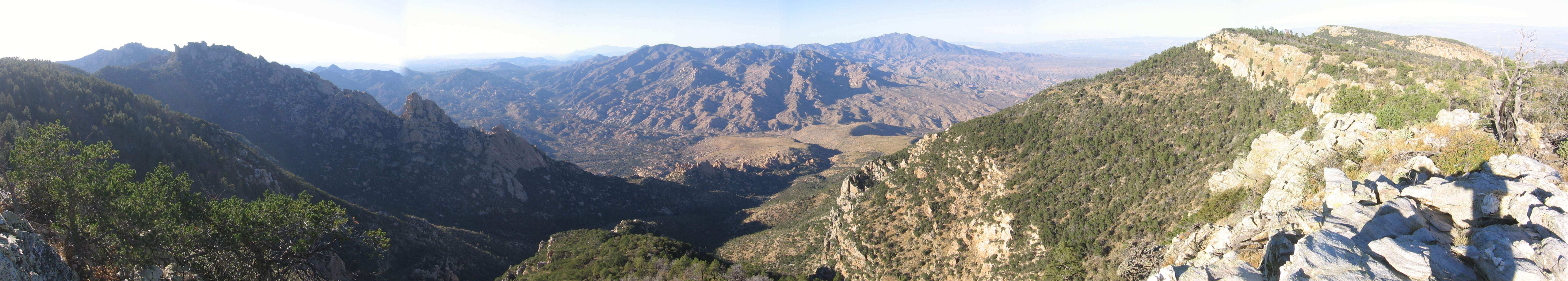
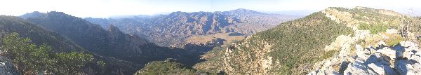 |
| Santa Teresa Wilderness
- click to view full-size (1 MB) |
| "Benedicto:
May your trails be crooked, winding, lonesome, dangerous, leading to the most
amazing view. May your mountains rise into and above the clouds. May your rivers
flow without end, meandering through pastoral valleys tinkling with bells, past
temples and castles and poets' towers into a dark primeval forest where tigers
belch and monkeys howl, through miasmal and mysterious swamps and down into a
desert of red rock, blue mesas, domes and pinnacles and grottos of endless stone,
and down again into a deep vast ancient unknown chasm where bars of sunlight blaze
on profiled cliffs, where deer walk across the white sand beaches, where storms
come and go as lightning clangs upon the high crags, where something strange and
more beautiful and more full of wonder than your deepest dreams waits for you
--- beyond that next turning of the canyon walls."
Edward Abbey |